North Adams Sets Redistricting Map for Colegrove School
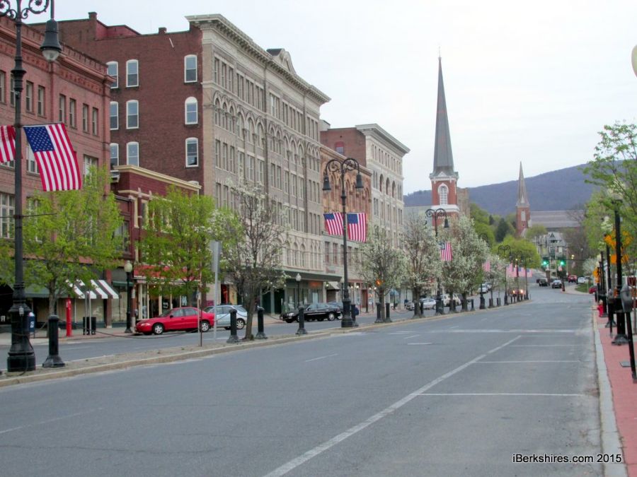 Main Street will be part of the new Colegrove Park Elementary School's district in recognition of housing development in the main corridor. Main Street will be part of the new Colegrove Park Elementary School's district in recognition of housing development in the main corridor. |
NORTH ADAMS, Mass. — The School Committee on Tuesday night approved a redistricting plan for the new Colegrove Park Elementary School. The plan is expected to affect about 100 children.
The committee modified the plan slightly to include the downtown commercial area.
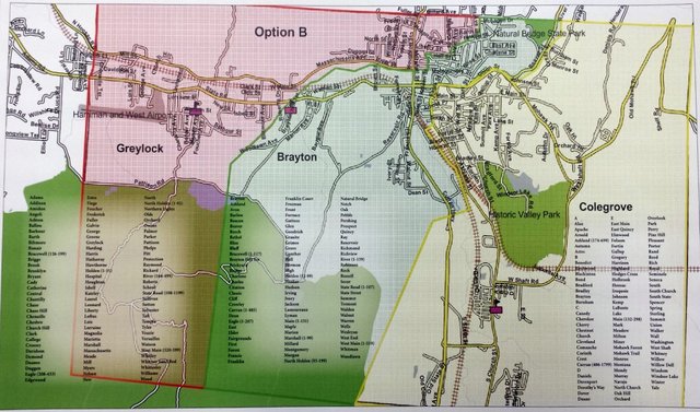
A larger image in pdf form can be found here.
The redistricting plan was done by Transfinder Corp. of Schenectady, N.Y., and used boundary lines, major landmarks and current school district lines to develop the new plan. The company offered three options (A,B, C) and believed "the overall concept of balancing enrollments between campuses was achieved in every option."
The committee selected "Option B," thought to be the least disruptive and most equitable.
Superintendent James Montepare had explained the options at last month's School Committee meeting, saying Option B was his preference.
"It evens everything out. I don't think it overcrowds everything," he said at the time."What it does is put 20 students in a classroom."
The renovated middle school will replace the 50-year-old Sullivan School off Kemp Avenue. Overcrowding has been an issue in three elementary schools since the closure of Conte Middle School six years ago.
The redistricting would move about 100 children out of Brayton Elementary. Projects would put about 294 in Colegrove Park, 291 in Greylock and drop Brayton to 303. Projecting out to 2020, the Colegrove would have the highest population at 355.
Another 94 children are waivered out of their school districts for various reasons, such as sibling daycare or parent workplace, so the number actually shifting may be lower. Colegrove will also be handicapped accessible, taking the pressure off Brayton to provide for that population.
Colegrove's district border roughly runs along State Street and Curran Highway north almost to Dean Street and then cuts over to Ashland Street north by the college then from Church Street to Union, encompassing neighborhoods to the west, southwest and northwest along the Beaver.
Brayton encompasses from Woodlawn and Brayton Hill Terrace east toward the downtown and north below Massachusetts Avenue and the south side of Hall Street and Franklin Street.
Greylock covers the West End and north above Massachusetts Avenue including Houghton Street, and the north side of Hall and Franklin Streets.
The School Committee approved the new plan with the condition that Colegrove's district included the downtown, which had been drawn to be part of the Brayton district.
Mayor Richard Alcombright said adding that zoning was really a development issue.
"If you're landlords in the downtown looking at housing development ... I would want to be able to market this thing as 'they have a school they can walk up Main Street to in four or five minutes.' "
There are no children known to be in that corridor, but the mayor noted that housing redevelopment was part of the Mulcare Building's plans and there was a push to increase downtown housing components.
The downtown was determined to be Ashland to East Quincy, American Legion Drive, and Eagle, Marshall and Holden from Main to River Street. The bulk of the properties within the corridor are commercial, with limited housing on Main and Eagle, Holden and Ashland right off Main.
Montepare said the change would not affect busing since any students within those boundaries would be walkers. There had been concern about children walking across Union (Route 2) to get to Colegrove school but the superintendent said children on the north side of the street would be bused to Brayton.
The map, however, may not change because the school district's contract with Transfinder is complete. Montepare said it could cost another $2,000 for a new map to delineate the small addition. It was decided to simply change the street list and, if possible, have someone try to modify the map.
With the boundaries settled, Montepare said he can meet with Dufour Bus to "make sure the routes jive as they should ... we're ready to roll with these."
The map and list will be posted in the schools and on the school district website but the mayor asked that any family affected by the change also be notified by letter. The School Department will review the redistricting plan next year to see if any modifications are needed.
Tags: North Adams School Committee, redistricting, school project,