Significant Snowstorm to Usher in More Cold Temps
.jpg)
First it snowed. Then it got warm. Then it rained a lot. Then it got cold. And now it's going to snow again — likely a significant amount, especially in the northern Berkshires.
The National Weather Service on Monday morning issued a winter storm watch from 1 p.m. Tuesday to 7 a.m. Wednesday for the greater region. Snow should start Tuesday afternoon, become steady by Tuesday evening, get heavier overnight and end by daybreak Wednesday.
So how much of the white stuff will we get from this storm?
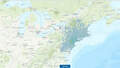
The Weather Service is calling for 6 to 12 inches of total snow accumulations. AccuWeather is predicting a couple inches Tuesday afternoon and evening with an additional 3 to 6 inches overnight in the North Adams region. Our friends at WNYT put Pittsfield north into a 5- to 9-inch zone and South County in the 2- to 5-inch zone, pretty much in agreement with the other Albany, N.Y., television stations.
But this storm — however much snow it dumps on us — is a one-two punch, ushering in frigid temperatures again. Wednesday's highs will only be in the teens, with Thursday's highs only in the single digits. Temperatures should go back to seasonably cold numbers for the weekend, however.
The latest snowfall forecast for the Northeast Tuesday into Wednesday as a snowstorm tracks over the region: https://t.co/JoZsEv5muE pic.twitter.com/E0G5bmnhCL
— AccuWeather (@breakingweather) January 28, 2019
On Early Today - get ready for another storm. Parts of the Capital Region could see a foot of snow tomorrow. https://t.co/bhmIDbd3yW pic.twitter.com/fq2uiiZUUm
— WNYT NewsChannel 13 (@WNYT) January 28, 2019
Tags: snowstorm, weather,