The Berkshires are in for a double whammy this week — a Nor'easter is expected to bring up to a foot of snow and ice overnight followed by another Arctic blast that will keep temperatures in the freezer zone.
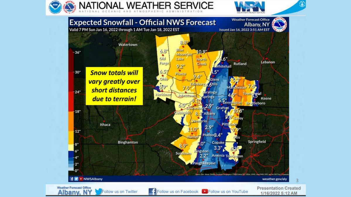
A winter storm warning is now in effect beginning Sunday at 10 p.m. and through Monday at the same time. The National Weather Service in Albany, N.Y., is forecasting 5 to 11 inches of snow and ice accumulations of up to a 10th of an inch. Winds could gust to 40 mph.
Adams, Clarksburg, North Adams (starting at 10 p.m.) and Pittsfield have so far declared snow emergencies and other communities may before the afternoon is over. Snow emergencies mean motor vehicles cannot be parked on the roadways during the storm to allow for plowing; in some communities public parking lots will be made available. Residents in North Adamsneeding assistance during the storm should contact Public Safety dispatch at 413-664-4945
The storm warning covers the Berkshires, eastern New York and northern Connecticut.
Snowfall rates of 1 to 2 inches per hour are possible between midnight and 7 a.m. The snow will later turn to a wintry mix of precipitation that could cut down the total accumulation of snow and create more hazardous conditions. The amount of snow will vary greatly depending on terrain.
Accuweather reported that lineman from Oregon were flying into Boston in preparation for the storm. The eastern part of the state is predicted to have damaging high winds and potential flooding. Eversource on Friday said it was prepositioning crews for both Sunday night's storm.
“We’ve been carefully monitoring these weather systems for the last few days and we’ll have workers and materials in position across the state ready to respond and will adjust our plans if the forecast changes,” said Eversource Vice President of Electric Field Operations in Massachusetts Bill Ritchie. “We’re fully stocked with extra utility poles, wire, transformers and other equipment and ready to repair any damage this storm may cause.”
National Grid tweeted on Sunday that it was "closely monitoring a storm expected to bring snow, rain & wind gusts of up to 55 miles per hour in MA & RI."
Monday is celebrated as Martin Luther King Jr. Day so schools and public offices will be closed.
Colder air will begin moving into the region Tuesday but Accuweather says the real blast will happen at the end of the week. The Midwest will get hit with lows in the minus-20s and the polar vortex will move into New England by Friday.
"These frigid conditions will spread eastward through the second half of the week with places like Boston, New York City and Philadelphia seeing the coldest day on Friday," AccuWeather Senior meteorologist Adam Douty said.
The jet stream will dip far south, leaving the Northeast in a deep chill through the end of January.
A blast of winter weather will impact big cities along the I-95, but hazards will shift over to heavy rain and strong winds as the storm progresses. https://t.co/anHyhseagrpic.twitter.com/AlQf5INkLV
— Breaking Weather by AccuWeather (@breakingweather) January 16, 2022
Our winter storm continues to crank into the northeast tonight-tue AM. Big snowfall for the interior northeast, cold rain for the I-95 corridor, and BIG wind for everyone.
As cold as it is now it still looks like a change to ice and even rain after an initial burst of snow. Snow starts a little before midnight then starts changing overnight. The further west and higher elevation the more snow. pic.twitter.com/51kK45l6j8
If you would like to contribute information on this article, contact us at info@iberkshires.com.
Your Comments
iBerkshires.com welcomes critical, respectful dialogue. Name-calling, personal attacks, libel, slander or foul language is not allowed. All comments are reviewed before posting and will be deleted or edited as necessary.
No Comments
Weekend Outlook: Spring Celebrations, Clean-ups, and More
By Sabrina DammsiBerkshires Staff
This spring weekend, there are a variety of events in and around the Berkshires, including Spring Celebrations, music, cleanups, and more.
Editor's Pick
Downtown Celebrates Spring Week
Downtown Pittsfield
Saturday & Sunday
There will be various events to celebrate spring, including a beach and tea party, and a free Kids' Paint & Sip event.
The featured event is "Where's Winston?" a spring scavenger hunt for images of the Pittsfield Police Department's comfort dog, Officer Winston, at a dozen downtown locations. More information here.
This spring weekend, there are a variety of events in and around the Berkshires, including Spring Celebrations, music, cleanups, and more.
click for more
More than 300 students from area high schools entered their work in 12th annual Teen Invitational at Massachusetts Museum of Contemporary Art. click for more
Backed by a $750,000 federal grant for a planning study, North Adams and Massachusetts Museum of Contemporary Art are looking to undo some of that damage.
click for more
"It wasn't 100 percent consistent but I was afforded the opportunity to get to know other people with different religion, beliefs, backgrounds and culture and to be able to embrace that." click for more
With the area warming up, events are blooming in the Berkshires this weekend, including an egg hunt, live music, fitness events, and more.
click for more