iBerkshire Storm Center: Hurricane Irene
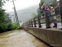 |
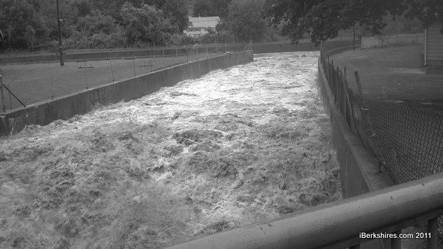
| The Hoosic River at Hodges Cross Road in North Adams. |
The iBerkshires Storm Team will update conditions as often as possible through Hurricane Irene and as long as we have power. Check here for postings and updates on conditions. Check our Twitter feed (@iBerkshires and on the righthand side of our front page) and Facebook page.
Any information, photos or videos of the storm can be sent to info@iberkshires.com, @iberkshires on Twitter or posted on our Facebook page. We are encouraging organizations or groups to post cancellations and closures on our FB page; the page is public so anyone can read it. We will do our best to get the all information out to the rest of the community
We urge people to stay safe and stay indoors. Don't drive if you don't have to and under no circumstances should you approach downed power lines. A full list of shelters and emergency numbers can be found here.
Friday, Sept. 2
4:50 p.m.
We have a short list of state parks and forests that have closed because of damage caused by Hurricane Irene.
Mohawk Trail State Forest and campground has closed for the season. The park is located on Route 2 in an area cut off by landslides and road damage.
Balance Rock State Park in the Pittsfield State Forest is closed, however, Pittsfield State Forest is open for day use.
Gardner State Park in Chester has closed its day area.
Natural Bridge State Park on Route 8 in North Adams is closed. A section of McCauley Road leading into the day park was washed out.
October Mountain State Forest in Lee has closed its day area.
Mount Everett State Park is closed through Labor Day.
Mount Washington State Forest day area is closed; the walk-in campground has limited access because of a washed-out footbridge.
Savoy Mountain State Forest and campground are open but only accessible by Route 116.
For a full list of closings, check the DCR listings here.
Thursday, Sept. 1
3:00
There are rumors making the rounds about the quality of the water in North Adams. While Windsor Lake was closed on Wednesday because of a high bacteria count from runoff from Tropical Storm Irene, the city's drinking water system is safe.
"Berkshire Enviro would have told me [about any problems with the drinking water ] when they told me about the lake," said North Adams Health Inspector Manuel Serrano. "We have a treatment plant and it's doing its job just fine."
11:30 a.m.
Governor visits Williamstown and The Spruces; takes a helicopter to meet with local officials in hard-hit Heath and Hawley.
10:17 a.m.
MassHighway has released a map of the road damage in the Berkshires:
The MassDOT Highway Division's office in Lenox reports more than 25 separate road locations with Irene-related impacts from roadway damage or flooding in Western Massachusetts, seen below, including along Route 2, Route 8, Route 20, and Route 112. Sections of roads are reopening as waters subside and repairs are made, while others await future repair.
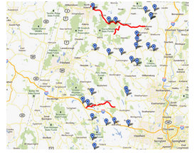
Check out the latest Google map of road conditions in Western Massachusetts.
Wednesday, Aug. 31
6:00 p.m.
Damage assessment teams are being deployed across Western Mass. and the Berkshires on Thursday, according to The Boston Globe. Cost estimates aren't expected until next week.
Gov. Patrick will tour Williamstown on Thursday, beginning at 11:30 at Town Hall. He will go to Heath for 1:00 and Hawley after that. Lt. Gov. Tim Murray will be in Buckland before joining him in Heath.
10:00 a.m.
North Adams Mayor Richard Alcombright has announced the closure of Windsor Lake (Fish Pond) to all swimming, fishing and boating effective immediately and until further notice. Because of the storm, bacteria levels have risen and the lake will continue to be monitored and tested on a daily basis. The picnic area of the lake will remain open for public use.
8:00 a.m.
The Spruces in Williamstown remains closed as state and local inspectors check each unit and repairs are made to the electrical system.
Tuesday, Aug. 30
6:16 p.m.
MassDOT reports the following state roadways in western Massachusetts and the Berkshires region remain closed as of midday Tuesday in the aftermath of Irene:
I-91 SB is closed between exits 26 and 24. Northbound is open. The detour is via Greenfield Rotary, Route 2A EB, River Road and Route 5 SB.
Route 5 in Northampton is closed due to the high water level. The detour is between Exits 17 and 18 on I-91.
Route 8 from Jct Route 23 in Otis to the Ct State Line in Sandisfield remains closed. Utility work is complete and lane shifts are being set up.
Route 20 Becket at the junction of Route 8 Bonny Rigg to Chester Center is closed due to roadway and structure damage.
Route 8 Clarksburg from Henderson Road to the Cross Road bridge is closed.
Route 2 is now open from Buckland to Charlemont MM 27.45 and from North Adams MM 12.7 to Florida MM 21.6. From Charlemont MM 27.45 to Florida MM 21.6 is still closed indefinitely awaiting inspections and assessments.
Route 112 Buckland is closed between MM 36.4 and MM 38.2 -.
Route 112 Colrain is closed at MM 46.2 due to road failure.
Route 7A Ashley Falls at mm 1.5 was closed last night at approximately 9:00 p.m. due to rising waters and remains closed.
Route 7 Sheffield from Lime Kiln Road to the Sheffield Depot MM 7.0 now has water subsiding. The road is flooded, but passable at this time.
4:00 p.m.
Clarksburg Elementary School and Gabriel Abbott School in Florida, and Stamford and Readsboro schools in Vermont, have delayed their openings until Tuesday, Sept. 6, after the Labor Day holiday. Flooding and washouts undermined roads in both towns causing a re-evaluation of bus routes.
Monday, Aug. 29
6:10 p.m.
Rainfall totals for Western Mass. from the National Weather Service and through WWLP.com
..MASSACHUSETTS...
SAVOY 9.10
SHELBURNE FALLS 8.50
TOLLAND 7.90
HEATH 7.70
GOSHEN 7.50
WESTHAMPTON 7.15
MILFORD 6.00
NORTH ADAMS 5.06
PITTSFIELD 4.53
GREENFIELD 4.30
NORTHAMPTON 4.02
WESTFIELD 4.29
SPRINGFIELD 3.20
Woodford, Vt., saw 7.15 inches of rain.
5 p.m.
Representatives from the Federal and state Emergency Management agencies, the state Department of Conservation and the Army Corps of Engineers have been touring damaged areas, according to local officials.
3:30
Update from Adams Town Administrator Jonathan Butler:
The town of Adams is under a State of Emergency until further notice.
Currently, the town is working to get any residents who were evacuated back into their homes. Few areas remain where residents have been unable to return. Largest current area of emphasis is Charles and Davis streets, along with homes down the northern side of Lime Street. Nobody was evacuated from this neighborhood, but damage to vehicle access is a major issue.
The Fire Department hit a call volume of more than 100 earlier this afternoon as a result of storm-related inquiries.
The town is encouraging all residents with storm-related damage on private property to do the following: Document and photograph, then bring that information to Town Hall. The Town will submit their damage requests as part of our relief assistance filing with MEMA. Residents should also contact their insurers as soon as possible.
East Road at Lime Street heading toward North Adams will remain closed indefinitely due to a washout that has eliminated half of the road and made the road impassable. Access from East Road down to Lime Street is operational.
East Hoosac has re-opened with narrow access, and the town still encourages folks to only use this section of road if necessary.
The town has had no storm-related injuries reported.
1:30
This information was posted on our Facebook page very early Monday morning and is from the Sherwood Forest Lake District:
Big Robin dam failed was an inaccurate report.
In preparation for the storm, the lake was lowered late last week. The intense rain Saturday night brought the lake up very high. The remaining boards were removed early Sunday morning. Continuous heavy rain brought the lake even higher so that eventually water came over the burm next to the dam. Becket officials visited the site and as a precaution decided to order a mandatory evacuation of downstream homes. As the day went on the rain eventually let up, the water receded, and folks returned home. Tonight the lake is still high but not overtopping the burm. Many roads were impassible, but are being worked on this evening to allow access to all parts of the Forest.
Note: Reports of the Big Robin Dam failing or in imminent danger of failing were widely reported by media and on social sites on Sunday, although there did not appear to be any official confirmation of that. Gov. Deval Patrick at a press conference on Monday said some dams had overflowed but did not break. "There are no confirmation of any dams being breached."
12:49 p.m.
Most recent list of state road and highway closures
District 1, Berkshire County
Route 8 from Jct Route 23 in Otis to Conn. state line in Sandisfield: Flooding subsided, closure because of trees with power lines down at multiple locations. The utility notified and some roadway structure damage must be assessed after daybreak
Route 20 from Becket at Junction Route 8 Bonny Rigg to Chester Center: Multiple roadway and structure damage, must be assessed after daybreak
Route 8 Clarksburg from Henderson Road to North Adams city line: 400 feet road failure
Route 2 North Adams from mile marker 12.7 to Buckland mile marker 38.1: Multiple roadway and structure damage, must be assessed after daybreak
Route 41 West Stockbridge at Baker Street: Tree with power lines down, utility notified
Route 112 Buckland mile marker 36.4 to 38.2: Roadway undermined
Route 112 Colrain mile marker 46.2: Road failure at the bridge abutment
Route 9 Pittsfield, Merrill Road from Plastics Avenue to RR crossing and Dalton Ave from Plastics Ave to RR Bridge, flooding
Route 8 Hinsdale from the junction of Route 143 to Buttermilk Road: Flooding
Route 7 Sheffield is restricted from Lime Kiln Road to the Sheffield Depot, mile marker 7.0
District 2, Northampton, Springfield
I-91 north- and southbound lanes remain closed between Exits 24 and 27. Detour is via Route 5, Route 116, Route 47, Route 63, and Route 2.
Route 5 in Deerfield is closed because of flooding.
Route 5 in Easthampton is closed because of flooding.
Route 5 in Northampton is closed because of flooding.
Route 20 in Palmer is closed at the railroad underpass
Route 20 Main Street in Westfield is closed because of roadway flooding and high water level of the Westfield River.
Route 67 in Warren is closed because of downed power lines, electric company was in Route at 4:00 p.m. Sunday
Route 20 in Palmer is closed because of to down power lines
Sunday
8:09
Update from the National Weather Service
Tropical Storm Irene was 30 miles northeast of Pittsfield at 6 p.m. The heaviest rain has ended but winds of 30-40 mph are still possible with gusts up to 55 mph.
Runoff is still a danger as some rivers and creeks continue to rise. A flood warning for the Housatonic River in Great Barrington was issued at 3:42. The river was at 7 feet at 3; flood stage is at 9. It was expected to reach flood stage at 5 p.m. and rise to 11.9 by 8 p.m., which could mean flooding of the main street.
The Hoosic River was beginning to lower after reaching 13.75 feet, nearly 4.5 feet above flood level, in the early afternoon. By 7, the waters had receded to 12 feet. The record was 14.7 feet.
A flood warning is still in effect for the region. Use caution and avoid low-lying areas that can flood quickly.
7:19
Just under 100 National Grid customers have just lost power in Williamstown; about 140 customers are out in North County, 300 in South County. About 1,250 Western Mass. Electric customers are still out of power.
7:00
Mayor Richard Alcombright Gives Storm Update
North Adams Mayor Richard Alcombright in conjunction with the city's Emergency Management Team continues to meet regarding the management of the storm conditions related to Tropical Storm Irene.

The team met at the Emergency Headquarters at the North Adams Ambulance Service at 4:30 p.m. to discuss the current status of the city. All departments including the North Adams Fire, Police, Health and Department of Public Works were on hand to provide updates. Also included were the North Adams Ambulance Service and North Adams Regional Hospital.
All aspects of the Emergency Plan were discussed. It was determined that 30 local residents were in the shelter at St. Elizabeth's Parish Center, that Fire and Police were handling the hundreds of calls that were coming in and that the Ambulance Service was providing emergency services as well as facilitating transportation to the shelter. The Department of Public Works has been reacting to the many water-related problems, such as road washouts and flooding in many of the lower lying areas.
During the event, Commissioner Morocco called the Massachusetts Emergency Management Agency who sent two National Guard units to the City to provide additional assistance to those needing transportation or support during the storm. Additionally, most North Adams emergency and DPW personnel have been working throughout the duration of this storm.
Mayor Alcombright stated that "Although this storm is coming to an end, the cleanup efforts will last for several weeks. I will be out with Public Safety and Public Services folks on Monday as they assess the damage and we will create a plan and set priorities for remediation. Many of our streets have been washed out or undermined by the sheer volume of water that our streams and storm systems could not handle."
The Mayor further stated, "The West End of the City and Massachusetts Avenue are and should continue to be very passable. The problem in the morning will be State Street and Ashland Street. People should avoid Ashland Street as much as possible and we are hoping to have State Street open by morning. In the meantime, Church Street to Hodges Cross Road to Route 8 might be the best route to the South. Additionally, Route 2 East is closed at East Main Street but is impassible just east of Dead Man's Curve until further notice."
Finally, the mayor states, "I want to thank all on the Emergency Management Team not only for their creation of a plan, but for the execution of that plan. These people are the only thing between us and true disaster and let us not forget how lucky we are."
The Mayor will meet with the press tomorrow in his office to discuss the scope of the damage and a timeline for remediation.
6:00
This video was taken earlier at the Eclipse Dam in North Adams and along River Street.
5:00
SPRINGFIELD, Mass. -- Western Massachusetts Electric Co. has made significant progress in restoring power to customers in the wake of Tropical Storm Irene.
As of 5 p.m., more than 13,000 customers have already been restored to service. Approximately 3,500 customers remain without power. Line and tree crews staged throughout WMECo's service territory will continue work throughout the night.
"The strength of the storm weakened substantially as it moved through WMECo's territory. We were able to mobilize quickly and efficiently to repair the damage to our system," said Peter Clarke, WMECo president and chief operating officer.
WMECo anticipates most customers should have service restored later tonight, although some outages in hard-hit areas may remain into Monday.
4:30
Update from Adams Town Administrator Jonathan Butler: Currently the water levels have gone down at the Lime Street, Hoosac Street and Cook Street bridges. The Town continues to closely monitor all of these areas, as well as several others.
The only current street closings are the following:
East Road from Lime Street to North Adams.
East Hoosac Street from Richmond Lane up to East Road.
All previously closed roads are reopened.
The town water supply is clean and safe. Some shutdowns occurred earlier in the day for a few homes due to nearby damage. The system is in good condition right now.
Currently, the Adams Fire Department has pumped 35 basements and is still working diligently.
No major injuries have been reported that are attributed to the storm in Adams.
The town continues to encourage people to stay off the streets and allow emergency personnel to have primary access. People are also encouraged to contact the Police Department if they have any serious concerns, and not to listen to misinformation being shared on social media sites such as Facebook. Much of this information has been incorrect.
2:30
Beaver Street evacuated from Union to the Clarksburg town line. Coury's Auto and The Range on Curran Highway are underwater.
About 20 people have sought shelter at St. Elizabeth's Parish Center. The city has cots, blankets, pillows, sandwiches and coffee available. Pets will be taken to the city's dog pound.
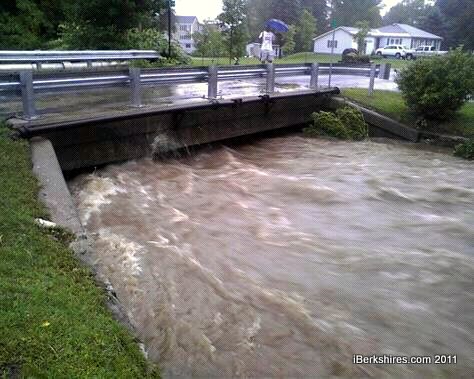
Emergency officials report no injuries so far from the storm. There is still chance of severe flooding and residents are urged to stay away from the flood control chutes over concerns of wall collapse.
The massive spill of mud and water pouring over the Eclipse Dam attracted a flow of gawkers who pulled to the side of the road and got out of their cars to take pictures. Police have strung yellow tape up and are asking people to stay behind the tape and the guardrails.
1:36
Water overflowing near Main Street and Flaherty in Cheshire, from Joe Durwin
 |
|
|
1:36
Mid-day update from state police :
Torrential rain is falling throughout the troop. As expected, the western part of the state is getting hammered. Several inches of rain have fallen already. Troop B has held over its mid-shift past its 0700 hours regular end-time. At this point there are approximately 50 troopers on duty in the western part of the state, including a K-9 unit.
• The State Police Barracks in Chesire is responding to a downed tree in the town of Washington that has brought down some power lines and caused a road to be closed. There are no other significant weather-related incidents ongoing at this time. State Police have deployed one of our amphibious tracked vehicles as well as a command post to Troop B for deployment as needed as the storm progresses. Our Air Wing is obviously not flying today but is standing by for damage assessment missions at daybreak Monday.
• The State Police Barracks in Russell is assisting with a tree across Route 23 in Russell, closing the road. The Westfield River in Chester is rising at fast rate, prompting evacutions of area neighborhoods and flooding on Route 20. There are also power lines down along Route 20 in Chester.
• The Farmington River in Otis is also flooded, causing flooding on Routes 23 and 8. , B-5, area reports a tree across the road Rte 23 in Russell, resources enroute, road temporarily closed.
• Several road closures are in place due to flooding, including stretches of Routes 8, 20, 23, and 57.
• Troopers from the State Police Barracks in Northampton are assisting with a tree across Route 91 near the airport.
• Troopers from the Shelburne Barracks are responding to numerous flooded roads and mud slides onto roads caused by torrential rains. The towns most affected are Rowe, Heath, Charlemont and Savoy.
• Sections of Route 2 are under several feet of water in the areas from Savoy to Buckland.
• Route 112 in Buckland is closed.
• Additional road closures to those listed above in the town of Peru.
• Widespread road closures in the towns of Huntington and Worthington.
• Robin Lake Dam in the Berkshires is spilling over.
• Evacuations are under way in the towns of Chester, Huntington and Otis.
1:15 p.m.
Update from Richmond
Emergency Management Director Tom Grizey says the town came through the storm fine. No one needed the shelter set up at the school so it was closed unless needed.
"The highest gust we had was 24 mph; we did get 5 inches of rain," said Grizey. There was some minor flooding in the usual places and "four little old trees" fell over. "We're doing very well."
1:00
From Town Administrator Jonathan Butler: The rumors that the water is being shut off in Town are incorrect. There has been some zones in Town on the Northeast side that have been damaged, and those houses may be experiencing low pressure. Other parts of Town are currently in tact and should be functional. More updates will come on this later in the day.
Current evacuations include Charles Street, Davis Street, North end of Lime Street, the blocks along Columbia Street and areas of Pine Street. People living in other areas that feel in danger are welcome to evacuate voluntarily to the Adams Memorial Middle School.
The Fire Department are available for pumping basements on properties of highest need. If the flooding is not significant they will have to move on to higher priorities until later in the day/tomorrow.
The Town is encouraging people to stay off the roads and allow them to be used solely for Emergency response vehicles and those evacuating.
The Town is also asking people to not stand on the bridges and stare at the water taking pictures, these are potentially dangerous areas.
This is a highly coordinated effort currently, the Town emergency services are working well together and have all hands on board.
The Middle School Shelter will remain open into the night. More updates will follow later in the day.
1:07
Clarkburg: Route 8 (River Road) closed from Mausert's to city line because of a washout. Daniels Road and East Road Bridge closed; Henderson Road closed for downed lines
12:32
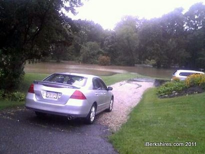
Flooding in back yards on West Housatonic Street in Pittsfield just past the Shell Station
11:40
We were sent this photo of the flood control chute in Adams near the Polish Picnic Grounds
11:30 a.m.
Roads are washing out across the region. Here's video from Stamford; East Road and parts of Main Road are impassable.
We've also learned that most roads in Adams are closed; downtown streets around Spring Street and Green River Road are closed from Main Street to the Store at Five Corners in Williamstown; Miner Street and West Shaft Road in North Adams; Main Road in Cheshire
9:00 a.m.
A small mudslide exposed a gasline on Miner Street in North Adams. Berkshire Gas was called and the street closed.

7:37 a.m.
Gradual onset of effects from Hurrican Irene began with light rain around 10 p.m. in Pittsfield. Winds grew overnight from 5 to around 20 mph by 6 a.m.
The National Weather Service has issued a Flash Flood Warning for Berkshire County effective through at least 10:45 a.m. Massachusetts Emergency Management reports that 181 people stayed in shelters throughout the state, and more than 1,500 utility customers experiencing power outages so far.
In the event any evacuation becomes necessary, shelter in Pittsfield has been provided at Reid Middle School on North Street (Route 7), a few blocks from Berkshire Medical Center. Shelter for pets is provided at the adjacent Springside House, which is located at the turn-off just south of Reid on Route 7.
7:00 a.m.
Hurricane Irene made landfall in New Jersey at about 5:35 a.m. It is a category one hurricane and estimated to have 75 mile-per-hour wind.
6:30 a.m.
At 4:52 a.m. the National Weather Service issed a flash flood warning for the county. The warning is in effect until 10:45 a.m.
The service's doppler radar picked up bands of heavy rain and thunderstorms at 4:42 a.m. that are embedded in the hurricane. Excessive runoff will cause small creeks and streams to overflow. If flash flooding is seen, move to higher ground.
Saturday
1:00 p.m.
Note: The emergency shelter has been moved to St. Elizabeth's Parish Center.
Checked out the emergency shelter at Drury High School. There are plenty of cots but no one was using them — yet.
Health Inspector Manuel Serrano said the shelter was opened earlier than planned because Hurricane Irene had been moving at a faster clip and was expected to hit the area some hours sooner.
 |
The shelter will remain open through the night and tomorrow, when the full force of the storm will be over the Berkshires. Two types of cots — camp style and mattress — are available along with blankets and pillows.
Serrano said people can bring their own pillows and blankets if they prefer, and snacks they may want. Sandwiches and coffee will be provided and the television is set up in the cafeteria. Those with prescriptions medications should bring two days' worth.
Emergency personnel went door to door along Beaver Street handing out voluntary evacuation information. The neighborhood is considered a likely flood area; heavy rain led to forced evacuation in the Beaver in 2005.
North Adams Ambulance General Manager John Meaney said the ambulance service was being fully staffed throughout the storm; the fire department and police were to begin adding personnel in the early morning hours.
Irene will bring heavy rain and high winds. Power outages, downed trees and wires and flooding are expected.
7:49 p.m.
Message from Pittsfield: Mayor James M. Ruberto declared a state of emergency in Pittsfield as of 3 p.m. Friday, after representatives from 11 city departments and Pittsfield Public Schools met with representatives from Western Massachusetts Electric, Berkshire Health Systems, Elder Services of Berkshire County, Vox Communications, County Ambulance, the Berkshire County Sheriff’s Office, and the American Red Cross, to establish an emergency response plan for Hurricane Irene, expected to hit the area over the weekend.
The storm is anticipated to strike during the day on Saturday, carry through Sunday, with increasing intensity Sunday afternoon and evening, and taper out on Monday. Recovery and remediation efforts will continue throughout Monday and beyond. On-street parking is prohibited during states of emergency. All City parking garages and lots will be open and available to residents throughout the weekend.
"We don't know what this storm will look like when it hits us, it's changing so fast," said Mayor Ruberto. "But what we do know is that we will be prepared for just about anything.
"The group that met today brought together departments and agencies from several different industries and arenas. They coordinated their individual emergency plans into a synchronized response plan that will help manage the situation as safely and effectively as possible, and it will keep all residents as safe as possible."
Approximately 8-12 inches of rain are predicted in this area, and any resulting flooding could be compounded by high rains in the surrounding states. Both Onota and Pontoosuc Lakes were drawn down in preparation for the additional water volume, according to Jim McGrath, the city's natural resources manager. City crews have been working for several days to clear all catch basins and minimize backup. Residents are asked to clear any new debris that collects on drains, but only if they can do so safely.
Pittsfield Fire Chief and Emergency Management Coordinator Robert Czerwinski said residents are encouraged to shelter-in-place by staying home as long as possible. If it becomes necessary to evacuate, people are encouraged to evacuate to a friend or relative's home.
If it is determined that an evacuation shelter is necessary, the city's primary shelter location will be Reid Middle School, at 950 North St. Its opening will be announced via local media, including the city's website, cityofpittsfield.org, Pittsfield Community Television, and WBEC AM 1420, and Live 95.9 FM. If there is a power outage, emergency announcements will be made on AM 1420, and 89.7 FM. Residents are reminded that if they have Internet-based (VOiP) telephone service, they will lose phone service if the power goes out.
The American Red Cross will manage the shelter, which will be equipped with cots, pillows and blankets, and Red Cross staff will provide basic First Aid treatment. Anyone evacuating to a shelter should bring several days’ supply of any required medications with you. Medications will not be available at the shelter.
In the event that the shelter is opened, a Disaster Animal Response Team will set up a shelter for household pets at the adjacent Springside Park. Animals will not be allowed in the shelter Reid Middle School.
John Tulloch, customer relations manager for WMECo, said residents are strongly urged to stay away from downed trees and utility wires, and should call 911 to report both. The proper authorities will check for downed wires and determine when it is safe to remove the tree.
Emergency response team members asked for residents' patience during the cleanup and recovery. The primary focus will be life-threatening emergencies, public safety, and keeping roads open for safety and security reasons. Debris removal and other non-critical situations will take last priority.
"This will be a multijurisdictional, multicommunity event that will impact a large geographical area," said Maj. Thomas Grady, of the Berkshire County sheriff's department. "Incidents of this magnitude and speed may quickly overwhelm available resources, and residents are asked to be patient."
"Please, stay home, stay off the roads, and stay away from downed wires, trees and puddles," said Chief Czerwinski. "You may think you’re splashing around in a puddle and having fun, but you could actually be playing in raw sewage."
The city asks residents to help minimize storm damage by trimming dead or hanging tree branches, and by securing or storing all outdoor items including furniture, decorations, plants, wind chimes, bird feeders, bird baths, lawnmowers, tools and any other items that could be dangerous if blown about by the storm. Residents are particularly asked to remove all political and/or advertising signs from their lawns. Household pets should be brought indoors.
Residents can also call Mass. 211 for more information, and to be directed to available resources in the Commonwealth.
6:00 p.m.
Pittsfield opens emergency shelter at Reid Middle School; pets can be evacuated to Springside Park. No animals will be allowed at the school. Check the police FB page for updates.
5:20 p.m.
Message from Bishop McDonnell of the Diocese of Springfield: Bishop urges parishioners to heed the advice of local emergency officials with regard to safe travel to Sunday Mass. If city/town officials indicate they wish people to stay off the roads then Catholics should consider themselves excused from their Sunday obligation.
3:59 p.m.
Dick Alcombright, Mayor of the City of North Adams has declared a State of Emergency for the City of North Adams due to the predicted severity of the approaching storm. The State of Emergency will be effective from 7:00 p.m., Saturday, August 27th until further notice.
EVACUATION REQUEST
The Department of Public Safety is requesting that the residence of Beaver Street and other flood-prone areas evacuate their homes in preparation of the impending storm and the certainty of dangerous flooding.
As a result, an evacuation shelter has been established at Drury High School and will open at 7:00 p.m. on Saturday, August 27th - The shelter will be staffed with cots, water, and medical supplies. If you are in need of transportation to the evacuation site, please contact the North Adams Ambulance at 413-664-4933.
All evacuees are asked to bring a blanket, pillow, basic essential clothing, medications, non-perishable food (granola bars, Gatorade, cookies, chips etcÂ…), eyeglasses, shoes and basic hygiene essentials.
If you have domestic animals and are transported to the shelter the City of North Adams Animal Control Officer will assist with arraignments for their safe keeping. Please provide animal crate if available with food and leash.
2:00 p.m.
As of 2:00 PM today, Adams has declared a State of Emergency. It will be effective until further notice. We continue to encourage people to stay off the streets.
Tags: disaster, storm,