Looking Back at Irene: Command Central

In a way, it started on Miner Street. A "mudslide" that exposed a gas line early Sunday morning. The event was duly reported by local media — but soon overwhelmed within hours by a cascade of disasters as muddy rainfall from Irene poured south into the Berkshires.
Communities around the region were prepared — at least as much as they could be — for the arrival of Irene, which had dropped to tropical storm status by the time it reached New England.
"We already had planned what we were going to do based on history, as far as what was going to happen in the downtown area," said North Adams Public Safety Commissioner John Morocco of such flood-prone areas as Beaver Street, River Street and the West End out to the Spruces Mobile Home Park. "We knew all this stuff ahead of time. We went around and told people, 'heads up water's coming your way.'"
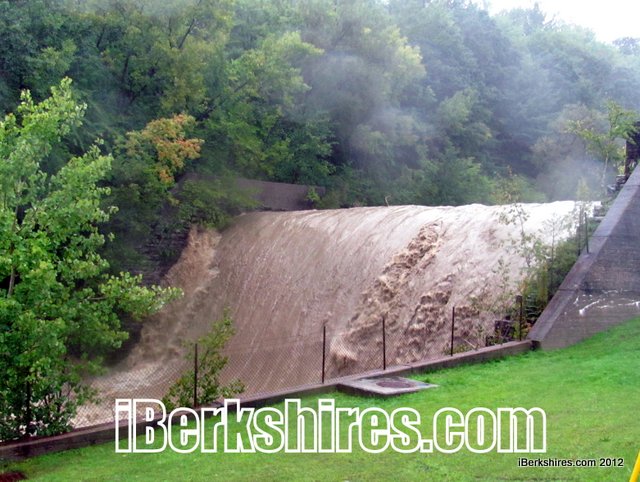
The concrete chutes cutting through the city are testimony to its watery experience. Built by the Army Corps of Engineers in the 1950s, the flood control system was designed to keep the Hoosic River contained as the North and South branches entered the city.
"We were pretty concerned we were going to lose our command center," said Morocco. "It came right up to the top of the wall and then it began to recede."
By late Sunday morning on Aug. 28, the 10-15 foot walls were in danger of running over and the aptly named River Street was rushing with water. Three hours later, the streets were dry but the chutes continued to churn and the Hoosic spilled over its banks into the nearest floodplain — the Spruces Mobile Home Park in Williamstown.
The command center was located at North Adams Ambulance Service, facing the river at the bottom of Harris Street. The water was reportedly clocked at 60 mph as the North and South branches fed into the chutes and barreled west toward Williamstown. It slammed into the concrete divider near where the Sprague plant on Brown Street used to be and sprayed up like a geyser.
"It was just incredible to see," said North Adams Mayor Richard Alcombright, "It didn't rain that long, but we were taking in everybody's [water]."
Beaver Street was evacuated — albeit reluctantly by some who refused to leave their homes until they were knee deep in water — and closed to traffic; the emergency shelter set up at Drury High School was shifted to St. Elizabeth's Parish Center as water undermined parts of West Shaft Road and came shooting across South Church Street near the Hoosac Tunnel and Hodges Cross Road.
Brayton School had been considered and dismissed as a shelter because of its location below the reservoirs, both of which had been drawn down only reach record levels after the storm. Emergency responders used boats to rescue residents on Galvin Road and the evacuation of Holy Family Terrace was considered.
The problem was the water was coming from everywhere.
"There were streams that were breached that we didn't even know existed," said Morocco. Public Works Superintendent Timothy Lescarbeau agreed: "We had water coming out of places I would never thought water would have come out of."
"[Highway Foreman] Paul Markland and myself were running around town," said Lescarbeau, who figured he changed out of wet clothes at least six times that day. "I think I burned off three tanks of gas that day just running from Point A to Point B. We were watching the flood chute in the West End and the water was this far from the wall. The whole ground shook. It's like nothing I'd ever seen before."
One of the results of the Irene is the installation of a new emergency notification system, Code Red, to provide residents with swifter updates. During Irene, notices were posted on the city website, and provided to the local radio station and other media.
"The issue remains how to get the information out," said Alcombright. A 30-second Reverse-911 messages literally takes days to send; with the new system, "we can pop a 30 or 40 second message out in 10 minutes to the whole community," said the mayor. "If you can do it that quickly, you can also give updates."
Citizens can sign up for text, email or phone messages on the city's website or here.
Morocco and Alcombright gave kudos to the many responders and others who worked that day to ensure everyone's safety — from the North Adams Ambulance and its manager John Meaney Jr. to the staff at North Adams Regional Hospital to the members of the emergency planning committee to city personnel. Officials also gave credit to state and federal agencies, especially FEMA.
"I still get emails from one of the gentlemen, 'how are you doing, do you need anything, can I get you anything?'" said Lescarbeau. "All of the agencies were awesome to work with."
Alcombright said weathering a hurricane hadn't been on his mind when he took office.
"No, but if something like that should come again I won't have the angst I had because I know just how well it was handled — both before to during and after — by the people of the city."