
Berkshire Communities Preparing for Storm's Worst
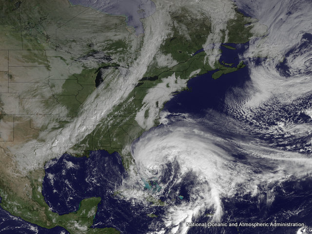 Hurricane Sandy is moving north along the coast of Florida in this satellite image taken Friday afternoon. |
"The storm's coming, we don't know what the impact of that storm's going to be," said Mayor Richard Alcombright on Friday afternoon at a meeting with the city's emergency team and the media. "We are probably more prepared than we were for [Hurricane] Irene because we know more now than we did. ... If this is an unfortunate event, a heavy event, then we are ready."
Hurricane Irene plowed through the Caribbean killing nearly two dozen before heading north parallel to the East Coast. Berkshire communities are mobilizing in preparation of the storm, cleaning out drains and culverts, checking equipment and fueling up. Reservoirs are drawn down and Windsor Lake in North Adams is being lowered as a precaution.
Williamstown officials have been meeting with residents of the oft-flooded Spruces Mobile Home Park and plan another meeting on Sunday when the forecast is clearer.
Pittsfield officials met Friday morning to "plan to plan," said acting Fire Chief Robert Czerwinski. He said Mayor Daniel Bianchi's emergency team is expected to meet again on Monday morning.
"No one is yet sure what path the storm will take," Bianchi said in a statement. "We're going to carefully monitor the weather, stay vigilant and be prepared."
Officials have good reason to be vigilant. Irene, which was downgraded to tropical storm by the time it rolled through the Northern Berkshires, eastern New York and Vermont last year, caused millions of dollars in damage to local communities.
As of Friday afternoon, the National Weather Service was predicting landfall along the Delaware coast, with the storm moving west before taking a northeast track; the outer bands will arrive in the region Sunday night. Experts with the National Oceanic and Atmospheric Administration are calling it a storm of historic proportions that will cover a third of the eastern seaboard.
Louis Uccellini, director of NOAA's National Centers for Environmental Prediction, said Sandy has some similarities to the "perfect storm" of 1991 as it is expected to be pulled in by a winterlike system to the north.
"There are signs that this one could have some of the same intensity factors and have a rainfall area larger than that one," said Uccellini at a teleconference with media Friday afternoon.
The storm is unlikely to change much in intensity as it approaches the coast over the weekend, said James Franklin, branch chief at the National Hurricane Center.
"It is expected to be a very large and slow-moving storm as it impacts many portions of the mid-Atlantic and Northeastern states in the early part of next week with large numbers of people being directly affected," he said. "Wind damage, widespread power outages, heavy rainfall, inland flooding, waves and storm surge all have the potential to affect large areas."
But while the storm is expected to sit over the region for several days, the Berkshires may be spared significant flooding if Sandy remains on the predicted path. The heaviest precipitation, including snow, will fall through Pennsylvania, western New York and parts of Ohio. That doesn't mean the Berkshires will be unscathed — plenty of rain is forecast.
|
Gov. Deval Patrick warned the state's utilities to be ready for Sandy or face fines, after last year's storms left citizens for days without power in many areas. National Grid said it's getting crews ready now for whatever comes.
"We are leaving nothing to chance; we’re preparing for the worst," said Kathy Lyford, National Grid vice president of electric operations in New England, in a statement released by electric company.
Adams officials are urging residents to take the event seriously and stock up on food, water and emergency supplies, and get any prescriptions filled. The Visitors Center will be used as an emergency shelter if necessary.
Local departments of public works are asking residents to avoid raking leaves into the roadways because they can plug drains. Adams residents can bring their leaves to the transfer station between 8 and 3 on Saturday.
North Adams Superintendent of Public Services Timothy Lescarbeau is encouraging residents to "adopt a drain" and ensure it's not blocked.
"We're as prepared as we can be at this point," said Lescarbeau. "It doesn't look like snow will be in the picture which is the best news my department could get."
Area residents can check their community's websites and Facebook pages for updates; local radio stations will also have information posted at regular intervals; and, of course, iBerkshires will provide updates on the website and Facebook page. If warranted, we will post our Storm Center on the front page with updates, cancellations, links and emergency information.
Tags: emergency preparedness, Irene, storm,