Henri Swerves Left, Bringing Rain, Wind to Berkshires
They're putting up the new flood barriers at Aquarium. @universalhub pic.twitter.com/bAzQD1L2bG
— Nicholas Bauer, PhD 👨🔬🔬 (@BioTurboNick) August 20, 2021
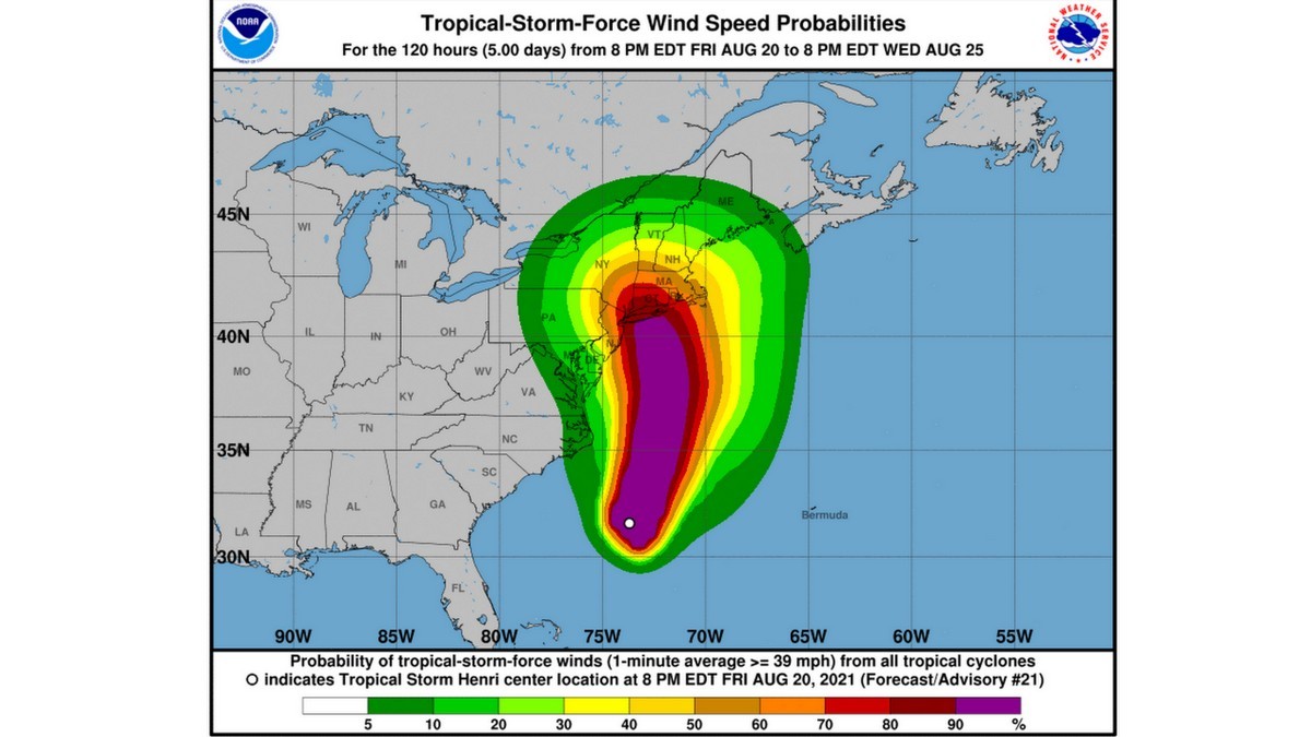
Tropical Storm Henri shifted left in is track to New England late on Friday, putting much of Long Island, Connecticut and Western Mass in the crosshairs. Currently at tropical storm level, it is expected to strengthen into a hurricane as it churns north on Saturday.
The storm was expected to arrive over the east end of the Bay State and have significant impact as far west as Worcester. But now landfall is forecast over eastern Long Island and through the center of Connecticut.
The Berkshire was forecast for heavy rain but now its expected to get anywhere from 4 to 10 inches from Saturday through Monday. The heaviest rainfall is forecast for Sunday afternoon into Sunday night. Wind gusts will reach 25 to 30 mph with gusts up to 40 in Southern Berkshire and parts of Connecticut.
The forecast for the Berkshires is cloudy on Saturday with a stray thunderstorm later in the evening and temperatures in the 80s. Sunday will be cloudy with a 25 percent chance rain, and much higher chance on Monday.
For now, the Susan B. Anthony daylong celebration in Adams is still on for Saturday; but Williamstown's Summer Sunday street fair is now canceled. We will list any updates on cancellations on the iBerkshires Facebook page.
Gov. Charlie Baker on Friday was urging residents to prepare for the arrival of the hurricane, which is expected to affect much of the state beginning Saturday night into Monday, including the potential for strong winds, heavy rain, flooding and power outages.
Visitors to Cape Cod and the islands were strong encouraged to cut their vacations short and leave by Saturday or to extend their plans into next week.
The National Guard was activated to fulfill high-water rescue, debris clearing and public safety support from impacted communities. The activation order allows for up to 1,000 guardsmen and will remain in place until support is no longer needed.
"I know that August weekends in Massachusetts are usually a great time to be outside and enjoy what's left of the rest of summer, but it looks like this storm is going to have a big impact on the commonwealth, and we really would urge everybody to do everything they can stay home on Sunday, and to be mindful of the fact that the high winds and the rain that come with the storm will in fact create issues across the commonwealth," Baker said during a press conference on the storm livestreamed from Boston.
The Berkshires are so far in the "hazardous weather outlook," according to the National Weather Service office in Albany, N.Y. NWS says there is a chance for thunderstorms Saturday through Monday, mainly during the afternoon and evening hours and there is the potential for flooding.
That could change depending on Henri's track, which on Friday has its center driving up the Connecticut/Rhode Island border, through east central Massachusetts and then along the south coast of New Hampshire.
The storm is about 700 miles south of New York City, which has a storm surge watch for the Bronx and Northern Queens. A tropical storm and surge watches also are in effect for southern Connecticut. The eastern end of the state and much of Rhode Island are under hurricane watch.
"This is the most serious hurricane risk in New England in 30 years, since Hurricane Bob in 1991," AccuWeather Chief Meteorologist Jon Porter said. Henri is rated a 1 on the AccuWeather RealImpact™ Scale for Hurricanes due to the anticipated rainfall, damaging winds and storm surge set to impact New England.
Massachusetts Emergency Management Agency Deputy Director Pat Carnevale said it was important for the public to prepare for storm conditions. Those in the path should make sure devices are charged, their gas tanks are full and they have stored outside furniture and other materials. More information on emergency preparedness can be found here.
"We've activated the SEOC, State Emergency Operations Center," he said. "We've also activated the two regional offices, one in Tewkesbury and one in Agawam, and those will be activated partially today, and then fully on Saturday and Sunday."
Carnevale said the team is in "constant contact" with the National Weather Service and has been getting briefings twice a day on the condition and track of the storm. The Federal Emergency Management Agency is also part of those conversations and resources — tarps, food, water, generators — are being positioned ahead of Henri's arrival.
National Grid said it positioning more than 3,000 personnel as part of its response team.
"Our message is simple and really, to reiterate what the governor said, we need to take this storm seriously," he said.
The goveror added, "So the shorthand is Sunday really should be a stay at home day for everybody who can make it one."
Henri is arriving one week before the 10th anniversary of Tropical Storm Irene, which hit Northern Berkshire, eastern New York, and Vermont hard on Aug. 21, 2011. Irene, which made landfall as a hurricane, damaged roads and bridges, swept away homes and trees, and flooded large areas.
Worst hit was the Spruces Mobile Home Park in Williamstown, which flooded when the Hoosic River overflowed its banks for the first time in decades. The retirement community was washed out and had to be abandoned; it is currently being used as a low-impact recreation area.
Some 13 miles of the historic Mohawk Trail was buried, broken, washed away, undermined or otherwise made impassable after the passage of Irene. The damage left small towns along the state highway isolated, their residents forced to take long detours to reach schools, stores and hospitals. It cut off North Berkshire from I-91 and Greenfield for the three months it took to rebuild the bridge, road and banks of the Cold River.
Someone is going to see 5-8 inches of rain from #Henri. The challenge is where. Inland flooding from this could be major in areas subjected to so much rainfall. pic.twitter.com/XtxwZl3rJ2
— Dave Epstein (@growingwisdom) August 20, 2021
. @ericfisher and I are watching that western trend in some models.
— Jacob Wycoff (@4cast4you) August 20, 2021
A western track would be a lesser impact storm for eastern MA, but worse for CT/NYC. pic.twitter.com/p2jwV5p8YN
Models keep shifting #Henri further and further west which is good news for the Cape and bad news for Long Island. (European model below) pic.twitter.com/JM6i7dGeR5
— Dan Brown (@dbrownweather) August 20, 2021
Tags: bad weather, hurricane,