
Messy Mix of Ice, Rain, Snow Expected Monday Night
A chilly rain for most of the Northeast Coast but more of a wintry mix with some ice (BOOOOO!) for parts of the interior Northeast. @LianaBrackett and I will time out the worst of the weather. 9am-1pm ET on the @weatherchannel. pic.twitter.com/rZSpzfG19q
— Alex Wallace (@TWCAlexWallace) November 18, 2019
The Berkshires missed any messy commute on Monday but that doesn't mean we're out of the woods. More sleet and freezing are on the way.
Forecasters over the weekend had warned of possible icy conditions on Monday morning that slipped on by us. However, there's a winter weather advisory in effect for Monday into Tuesday at 10 a.m. for freezing drizzle that could start by the afternoon.
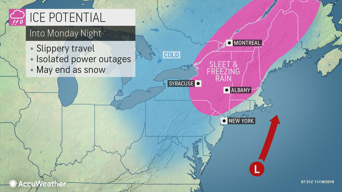
"Areas of freezing rain after sunset will gradually turn to sleet and snow after midnight," cautions the National Weather Service's Albany, N.Y., bureau. "Total snow accumulations of up to one inch and ice accumulations of around one-10th of an inch."
Accuweather says a storm will be battering the eastern seaboard while an icy mix of sleet, freezing rain and snow will be falling Monday night over the Berkshires and eastern New York and Southern Vermont.
Lows will be hovering just around the freezing point during the night hours before climbing a few degrees into the high 30s during Tuesday. It does look like the unseasonable could will retreat a little, with highs in the low 40s by the end of the week.
But Thanksgiving week isn't looking so hot, with three potential storms lining up to bring rain, ice or snow — depending on where you live or where you're heading. The Transportation Security Administration is expecting more than 26.8 million passengers to fly to grandmother's house or other destination beginning Friday and through next week, with more than 4 million this weekend alone. Another 49 million will take to the roads.
A Winter Weather Advisory is now in effect for the central Mohawk Valley, northeast Catskills, Schoharie Valley and Helderbergs beginning at 5 pm until 10 am Tuesday. Winter Weather Message: https://t.co/vsLDNGKHnw #nywx #ctwx #mawx #vtwx pic.twitter.com/c6tsdYGoSf
— NWS Albany (@NWSAlbany) November 18, 2019
Evening commutes in the Southern part of VT may be difficult & travel overnight will be a challenge across the state.
— Vermont Agency of Transportation (@AOTVermont) November 18, 2019
VTrans will be out in force, but it only takes a small patch of ice to make a difference. Be sure to reduce your speeds & leave yourself plenty of time & space. https://t.co/7HKqwXKFwm
Tags: bad weather,