The National Weather Service in Albany, N.Y., has issued a high wind warning from 6 p.m. Thursday into the afternoon on Christmas Day.
The forecast is for damaging winds of up to 70 mph that could blow down trees and power lines. NWS is predicting widespread power outages and difficult travel conditions.
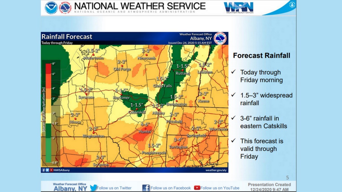
The storm will be accompanied by heavy rains that could cause flooding in low-lying areas. The Massachusetts Emergency Management Agency is warning of 2 to 3 inches of rain between Thursday and Friday night.
The city of North Adams issued a Code Alert asking for residents to prepare for power outages by charging phones and other devices, bringing in inflatable and holiday decorations and yard furniture, and limiting travel. City residents should contact police dispatch in case of emergency at 413-664-4944, and limit travel.
Damaging winds will blow down trees and power lines widespread power outages are expected. Travel will be difficult, especially for high profile vehicles.
National Grid reports its preparing for the powerful storm and that power outages could take days to restore.
"We have canceled employee vacations, secured additional crews, and put emergency plans in place in anticipation of this severe, ill-timed storm," said Michael McCallan, vice president of electric operations for New England in a statement. "We're prepared for the storm and its aftermath. We recognize that no outage is convenient, and we’re particularly conscious of the timing of this storm, when so many of our customers will be celebrating the holidays at home during what continues to be a challenging year."
Nearly 1,700 field-based workers in New England have been secured as part of National Grid’s emergency response operations. This includes overhead line, forestry, contractors, underground, damage assessment, wires down, transmission, and substation workers.
The company says it has been preparing for the storm for days, and is continuing to monitor the weather, communicating with local officials, first responders, and life support customers.
The heavy rains will be followed by a deep freeze as a massive storm system that has resulted in blizzard conditions over the Midwest moves toward the Atlantic Coast. Temperatures are expected to dip into the 30s in the state of Florida.
"Advancing cold air will continue to catch up with the back edge of a storm and a trailing cold front in the Central, Southern and Eastern states, causing wintry weather and a slew of hazards for motorists," cautions Accuweather.
Tonight into Christmas Morning, near Record Warmth....
Temps climbing to 55 to 60....then falling rapidly in the afternoon.
Here are the expected High temps and Christmas Day Records.
Widespread 2-3 inches of rainfall forecast between tomorrow night and Friday night. STRONG gusty winds will accompany this rainfall as well. NUMEROUS power outages are possible. pic.twitter.com/hpAmRFD9r2
We’re ready for tomorrow’s storm, and encourage you to prepare for severe weather by assembling or restocking a storm kit with essential items. Here’s what you need:
If you would like to contribute information on this article, contact us at info@iberkshires.com.
Your Comments
iBerkshires.com welcomes critical, respectful dialogue. Name-calling, personal attacks, libel, slander or foul language is not allowed. All comments are reviewed before posting and will be deleted or edited as necessary.
No Comments
Winter Storm Warning Issued for Berkshires
Another snowstorm is expected to move through the region overnight on Friday, bringing 5 to 8 inches of snow. This is updated from Thursday's winter weather advisory.
The National Weather Service in Albany, N.Y., has posted a winter storm warning for all of Berkshire County and parts of eastern New York State beginning Friday at 4 p.m. through Saturday at 1 p.m.
The region could see heavy to moderate snowfall rates of 1 to 2 inches per hour overnight, tapering off Saturday morning to flurries.
Drivers should exercise caution on Friday night and Saturday morning, as travel conditions may be hazardous.
Saturday night should be clear and calm, but warming temperatures means freezing rain Sunday night and rain through Monday with highs in the 40s. The forecast isn't much better through the week as temperatures dip back into the teens with New Year's Eve looking cloudy and frigid.
Many homeowners are showing their holiday spirit by decorating their houses. We asked for submissions so those in the community can check out these fanciful lights and decor when they're out.
click for more