The Berkshires are expected to get hit with up to 6 inches of snow as the leading edge of a 1,500-mile storm system moves in the region on Tuesday.
The National Weather Service in Albany, N.Y., has issued a winter weather advisory for the Berkshire and Southern Vermont beginning noon Tuesday through 10 a.m. on Wednesday.
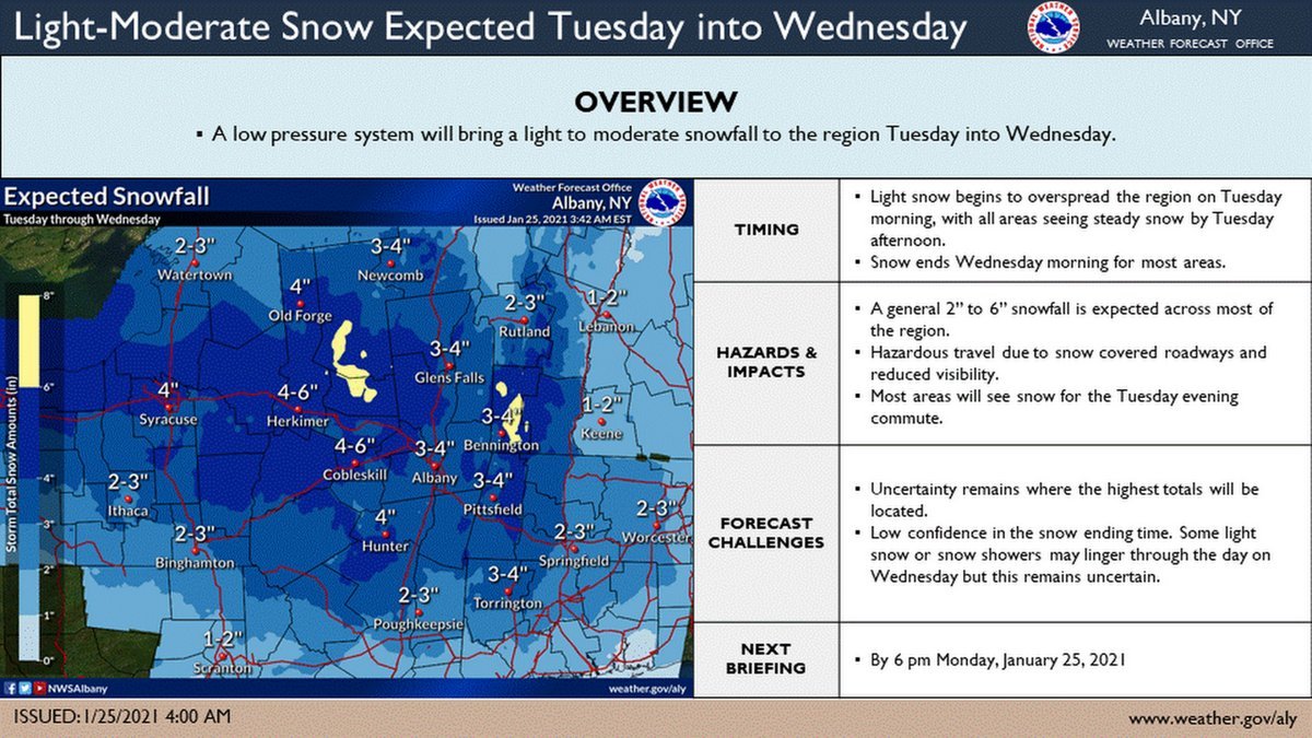
NWS is forecasting total accumulations of 3 to 6 inches with up to 8 inches possible in some higher-elevation portions of eastern New York. Snowfall could fall as fast as an inch an hour during Tuesday afternoon.
Snow Emergencies
• The city of Pittsfield has declared a snow emergency from 7 a.m. on Tuesday until 7 p.m. on Thursday. City residents are reminded of the alternate parking scheme for snow emergencies: park on the even side of the street from 7 a.m. Tuesday through 7 a.m. on Wednesday; then switch to the odd side through 7 a.m. on Thursday.
• Adams has declared a snow emergency from 5 p.m. on Tuesday through noon on Wednesday. There is no parking on the street or in the public parking areas during this time. Sidewalks must be cleared within 24 hours of the storm's ending and residents are encouraged to clean around fire hydreants near them.
• North Adams has declared a snow emergency from 5 p.m. Tuesday to 2 p.m. Wednesday. Parking is not allowed on public streets during this time and residents are asked to clear sidewalks and fire hydrants near their homes.
Accuweather says this system originated off the West Coast and is expected to disrupt travel in a 1,500-mile belt stretching from to the Atlantic Coast.
"Precipitation will gradually spread from south to north through the mid-Atlantic Monday night into Tuesday,"
explained AccuWeather Meteorologist Rob Richards. "The Monday evening commute could be at risk of becoming very messy around Baltimore and Washington, D.C. Travel Tuesday morning in areas New York City to Philadelphia could be delayed."
While the heaviest snow totals are expected to remain farther west in the Midwest, there could still be a small pocket of 3-6 inches in the Northeast as well, most likely in the mountains of northern Pennsylvania and portions of New York state, according to Accuweather.
The snow is expected to taper off by early Wednesday morning but there's a chance of snow showers later in the day. Thursday is expected to be partly sunny with highs in the low 20s.
For Tuesday, plan on slippery roads and times of reduced visibility.


.jpg)