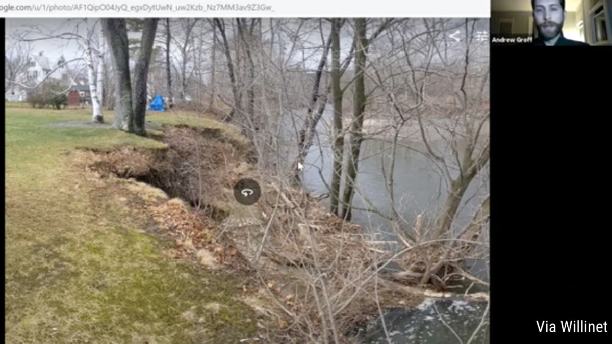
Christmas Eve Storm Damaged Hoosic Riverbank in Williamstown
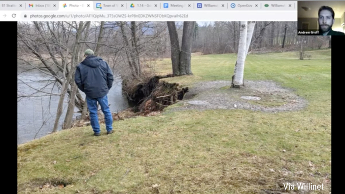
Looking south at the erosion along the Hoosic River in Williamstown. The two manholes visible in the photo recently were abandoned as part of a rerouting of sewer lines necessitated by the same weather event that caused the erosion.
Last week, the chair of the Conservation Commission informed his colleagues that he had issued an emergency certification to allow reconstruction of the lines near the intersection of Syndicate Road and North Street (Route 7).
Lauren Stevens said he and Conservation Agent Andrew Groff reviewed the scene and OKed the realignment of sewer lines near the river.
"There is a tangle of sewer infrastructure on the site," Groff said, showing the commission a diagram during its virtual meeting. "Really heavy rainfall and snowmelt on Christmas Eve caused a significant amount of water infiltration into this 12-inch main off the North Street neighborhood. This ties into a 24-inch main that comes down from, essentially, the Mission Park dorm. This line is the 48-inch pipe from North Adams.
"This pipe does this weird little jog and it comes to a manhole here and then backs up, drops into the 24-inch here. This system is smaller than the rest of the pipe. It clogged and discharged raw sewage into the Hoosic, unfortunately, because of the rain event."
After Groff and Stevens issued the emergency certification, the town's Department of Public Works was able to address the issue when the weather allowed in early January. It removed the "jog" Groff referred to and installed a straight line of adequate size to handle the flows.
"It's really a modern and more well-designed connector," Groff said. "The Water Department believes this will prevent any future discharges into the Hoosic. We do not want to have that happen again."
Work on the sewer line was completed on Jan. 14, Groff said.
"I do want the commission to know that longer-term, we do have a pretty serious issue on this site," Groff said. "There was some significant erosion here during the Christmas Eve storm."
Groff showed the commissioners dramatic photos of trees that now are practically in the river but were, on Dec. 23, 2020, high up on the bank.
He said the town is talking with the Army Corps of Engineers about doing a bank stabilization project at the site, similar to one the Corps completed upstream along the Hoosic about 20 years ago.
"We'll probably be before the commission [on the bank stabilization] at some point, but it's going to require not just local permitting but a whole alphabet soup of state and federal agencies," Groff said.
Since the rerouting of the sewer lines in early January moved them away from the freshly eroded bank, that system is not in immediate danger from further erosion, Groff said. But the hope is that the land can be stabilized to prevent further loss of land at the site.
"At my invitation, one emeritus geoscientist from Williams and two current geoscientists did look at this site from across the river," Stevens said. "They felt there was no magic solution to this. As the town had diagnosed, there's an immediate problem of preventing the rest of that bank from caving in. But then there is the long-range problem, which might include continuing the armoring that is further upriver."
Groff said the town has engaged local engineering firm Guntlow & Associates to look at short-term steps the town can take on its own while also engaging with the Army Corps of Engineers to look at a more permanent solution.
In other business at its Thursday meeting, the Conservation Commission:
• Informed a property owner on Stratton Road that their plan to build a home is subject to the Wetlands Protection Act because of the presence of an intermittent stream on the edge of the site and 25 feet from the proposed building's footprint.
The commissioners raised concerns about the lack of specification for how the proposed building would handle discharge from roof drainage or a basement sump pump that the commissioners felt would be required to keep a planned rec room dry at the site.
The commission's positive determination of the WPA's applicability triggered the need for the owner to do more detailed engineering under the Notice of Intent process to proceed with construction.
• Approved the replacement of a septic system on Sloan Road, near the Green River, but conditioned the work on better management of bordering vegetative wetland. The commissioners noted during a site visit to review the septic system project that the vegetation near the river's edge was not properly maintained.
"I, frankly, found the plans for the septic system to be up to snuff and have no objection to any of that," Hank art said. "But I do object that the bordering vegetated wetland has been mowed, just mowed down."
The commission approved the application with the condition that the BVW be left in its natural state and that there be no expansion of the current lawn at the site.
• Continued until an April meeting a hearing on an NOI from the town to improve a stormwater detention basin adjacent to 224 Longview Terrace. Engineer Charlie LaBatt of Guntlow informed the commission that defining the wetland boundary for the site -- first discussed at the commission's December meeting -- will be easier after the spring thaw.
• Approved plans for the demolition of a home, shed and two barns at 633 Northwest Hill Road
• Briefly discussed the Massachusetts Department of Transportation's proposal to put a roundabout at the junction of Routes 7 and 43 in South Williamstown.
Art asked the commission to consider at a future meeting how that project could impact Bloedel Park, a small town-owned parcel at the Five Corners intersection that is under the custody and control of the commission. Specifically, Art speculated that the MassDOT plan could involve a "taking" of town land.
Groff said that he knows MassDOT is aware of the park and likely would want to involve the proceedings triggered by Article 97 of the state's constitution to take land out of conservation. But he noted that the project -- if it happens -- likely would be jurisdictional for the commission because of its proximity to the Green River. And he said he would check with the state agency to see if a preliminary discussion with the Con Comm could be arranged.
MassDOT is in the early stages of considering a traffic circle to improve safety at the site. It is welcoming public comments on the idea through a "virtual meeting" through Feb.3.
Tags: conservation commission, Hoosic River, riverbank,