If you would like to contribute information on this article, contact us at info@iberkshires.com.
Your Comments
iBerkshires.com welcomes critical, respectful dialogue. Name-calling, personal attacks, libel, slander or foul language is not allowed. All comments are reviewed before posting and will be deleted or edited as necessary.
No Comments
Snow, Frigid Temperatures Ring in New Year
Prepare for a cold and snowy arrival of 2026.
A winter weather advisory was issued by the National Weather Service in Albany, N.Y., beginning at 7 p.m. New Year's Eve through 10 a.m. on Thursday for Northern Berkshire and Southern Vermont.
The forecast is for snow accumulations of up to 5 inches, with more possible in the higher elevations of the Green Mountains.
Roads, and especially bridges and overpasses, will likely become slick and hazardous. Plan on slippery road conditions, especially tonight during any travel for New Year's Eve celebrations.
Snowfall will be light to moderate with an Arctic cold front moving through the region. This will result in snow squalls during the pre-dawn hours. There's a chance of show showers continuing through Thursday morning.
New Year's Day will arrive will temperatures in the low 20s and wind chills as low as zero. The cold air will continue through the weekend, dropping into the single digits at night.
A system looking increasingly similar to Christmas Eve will bring a thump of snow to eastern Maine with lighter snow elsewhere. A secondary area of enhanced totals will be possible near the South Shore as well. #MAwx #CTwx #RIwx #NHwx #MEwx #VTwx newenglandstormcenter.substack.com/p/thump-of-s...
Samuel Currence served his country in the Air Force with distinction, professionalism and unparalleled humility from 1962 to 1985, retiring as a technical sergeant. click for more
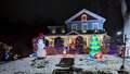
Many homeowners are showing their holiday spirit by decorating their houses. We asked for submissions so those in the community can check out these fanciful lights and decor when they're out.
click for more