Today, Massachusetts Department of Conservation and Recreation (DCR) Commissioner Stephen H. Burrington announced that $21.3 million in state funding has been allocated by the Romney Administration through the Executive Office of Environmental Affairs (EOEA) for the Historic Parkway Rehabilitation at Mount Greylock State Reservation in northern Berkshire County.
“This project is the largest single capital improvement project ever undertaken in the Massachusetts state park system,†said Commissioner Burrington. “It is fitting that this work will be done to restore the historically significant parkway at Mount Greylock, the Commonwealth’s highest peak, one of the Berkshire’s most popular tourist destinations, and state park system’s first acquisition, back in 1898.â€
The 13.5 miles of historic parkway at Mount Greylock consist of three roads: Rockwell Road (7.3 miles), Notch Road (5.72 miles) and Summit Road (0.77 miles). The parkway’s winding route, naturalistic design and spectacular sequence of vistas reflect the design and craftsmanship of the Civilian Conservation Corps (CCC), a Depression-era public works program. Corps members completed the roads in 1939. The goal of the project is to rehabilitate the historic parkway system in a manner that balances safety, recreation, conservation and historic landscape preservation.
The scope of the rehabilitation project will include:
* Repairs to bring the roads to current transportation and safety standards
* Rehabilitation of historic features including overlooks, stone walls, culverts, and vistas
* Replacement of concrete bollards with historically appropriate steel-backed timber guardrails to simulate the original CCC-built timber barriers
* Repair of the drainage system
* Installation of a septic line under the Summit Road for future use
* A plan for future removal of obtrusive overhead electrical lines at the Adams Overlook on Summit Road
* A plan for interpretive features to enhance overlooks and other locales.
“I am excited to see the state investing in the State Park System and specifically in its flagship park, Mount Greylock,†said State Representative Denis E. Guyer. “Once completed, these repairs will make Mount Greylock a safer place and more enjoyable for everyone who uses it.â€
“Fixing the Mount Greylock Historic Parkway is critical to the safety of the thousands and thousands of visitors who head up the mountain,†said State Senator Andrea F. Nuciforo, Jr. “This project will also contribute significantly to the local economy, and will further enhance the experience for those who visit our state's highest peak.â€
“This has long been in the works. Mount Greylock is the crown jewel of our state parks and is one of our area's great assets,†said State Representative Daniel Bosley. “I'm glad to see it is finally getting the rehabilitation it deserves.â€
Project designer Vollmer Associates, LLP originally developed plans for the project in 2002 when the parkway restoration at Mount Greylock was one of two Demonstration Projects of the EOEA Historic Parkways Initiative, the other being the rehabilitation of Memorial Drive in Cambridge. With the availability of project funding, spread out over the 2007, 2008 and 2009 fiscal years, DCR was authorized to enter into contract with Vollmer to update the project design and renew permits.
Solicitation of bids was issued in October 2006. Bids are due by December 13, 2006, and the construction contract is expected to be awarded in January 2007, with construction work expected to begin in April 2007. The entire project is expected to be completed by June 2009. Construction is estimated to cost $18.9 million, with the remainder of the $21.3 million overall budget going toward design and environmental services.
“On behalf of the Mount Greylock Advisory Council, we are extremely pleased that the road reconstruction project is moving forward. Mount Greylock is the most spectacular natural vantage point in Massachusetts and the road permits visitors who cannot hike to the summit an opportunity to enjoy the experience,†said Barry Emery, Chairman of the Mt. Greylock Advisory Council. “Furthermore, Greylock's roads were constructed by the Civilian Conservation Core and are an historical artifact worthy of our care and maintenance. From the council I extend our thanks to the Commissioner, our Berkshire congressional delegation, and Bob Mellace, the DCR Western Regional supervisor, for their combined efforts in bringing this project to fruition.â€
Due to seasonal constraints, construction will occur between April 1 and November 1 as weather permits. Mount Greylock roads will be closed to the public for the 2007 and 2008 seasons. Road closures during construction will provide substantial financial savings as well as speeding up the time it will take to complete the project. The Visitors Center on Rockwell Road in Lanesborough will remain open during construction.
During construction, while roads are closed to the public, trails on the state reservation will be open to walkers, hikers, and mountain bikers. As construction work is not expected to take place during the winter months, winter activities such as cross country skiing, snowmobiling and winter camping are not expected to be impacted by the parkway rehabilitation project.
Sperry Road Campground will be open to backpack campers only. Reservations will be limited to two-night stays and can be made through the ReserveAmerica online reservation system (reserveamerica.com). Car campers will be directed to nearby DCR campgrounds at Clarksburg State Park, Savoy Mountain State Forest and Mohawk Trail State Forest.
DCR plans to work with state and regional tourism officials and non-profit organizations such as the Appalachian Mountain Club and the Appalachian Trail Committee to notify tourists, residents and visitors to Mount Greylock regarding plans to close the roads up the mountain during construction. DCR will also have updates on the project posted on the agency website at www.mass.gov/dcr. Park staff will also work with local organizations, institutions and businesses which have sponsored annual events at Mount Greylock to determine which events can be held during the construction period and which may have to temporarily move to another DCR park facility.
In addition to the $21.3 million in state funding for the Historic Rehabilitation Project, DCR is working with the Massachusetts Executive Office of Transportation to secure $862,290 in federal funds toward a secondary phase of the project. The federal funds were secured by U.S. Congressman John Olver through the Transportation Community and System Preservation Program in 2006.
The Summit of Mount Greylock State Reservation, which is listed on the National Register of Historic Places, features a number of CCC-era structures, including Bascom Lodge, the Thunderbolt Ski Shelter and the scenic vistas and the historic War Memorial Tower. Bascom Lodge and the War Memorial Tower will be closed during the reconstruction project.
If you would like to contribute information on this article, contact us at info@iberkshires.com.
Your Comments
iBerkshires.com welcomes critical, respectful dialogue. Name-calling, personal attacks, libel, slander or foul language is not allowed. All comments are reviewed before posting and will be deleted or edited as necessary.
No Comments
Dalton Considers Digitization of Records
By Sabrina DammsiBerkshires Staff
DALTON, Mass. — The town is exploring digitizing its records to improve documents organization and accessibility, while reducing the need for physical storage space.
Digitization and storage is an issue that the town encounters, more often than they would like, and has become increasingly apparent through the ongoing work of the Stormwater Management Commission, Chair Thomas Irwin told the Select Board in April.
"[The commission has] repeatedly struggled to determine what documents exist, access past commission records, and identify a secure searchable location for records we continue to generate," he said.
Currently, the town's Municipal Separate Storm Sewer System (MS4) documents are primarily stored on a Google documents account managed on a Berkshire Regional Planning Commission computer and, to a lesser extent, the stormwater management webpage, Irwin said.
"For obvious reasons, this is concerning. As Dalton moves toward full MS4 compliance, both the number and the size of these records will increase," he said.
He estimated that the stormwater commission alone will initially store at least 50 documents, but the issue extends farther than this department.
"Recently, the Planning Board spent many hours searching for the east of the pond drawing and the 1992 land court decision related to Crane and Company, Petricca Industries Inc., and the Town of Dalton," Irwin said.
Cassidy Flynn scattered five hits in a complete-game effort in the circle as Lenox upset top-seeded Hoosac Valley, 3-2, in the quarter-finals of the Division 5 State Tournament. click for more
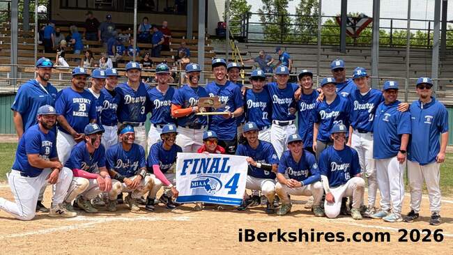
Brayden Durant struck out seven and walked one in a complete-game effort on the mound Saturday to pitch the Drury baseball team to a 6-0 win over Keefe Tech in the quarter-finals of the Division 5 State Tournament at Joe Wolfe Field. click for more
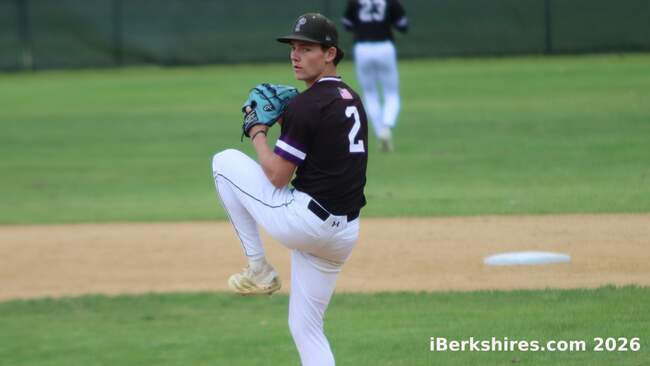
Jason Codey struck out 13, walked two and allowed just an infield single as the Generals earned a 7-1 win over Wahconah to claim their third straight regional title. click for more
Gracelyn Wright struck out eight, and Genevieve Lagess went 3-for-5 with four runs batted in as the Hurricanes beat Monson, 17-3, to claim their first Western Mass title in four years. click for more
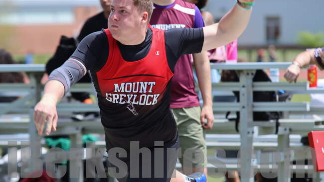
For the boys, Ward Bianchi helped lead the way with a win in the shot put and a second place in the javelin as the Mounties finished 16 points ahead of runner-up Pittsfield (pending the results of the pole vault, which were unavailable at 11 p.m. Friday night). click for more