Williamstown Conservation Commission OKs Patch Work on Route 43
WILLIAMSTOWN, Mass. — The Massachusetts Department of Transportation this month will do some repair work on Route 43, but a full rebuild of Water Street south of Latham Street is still several years away.
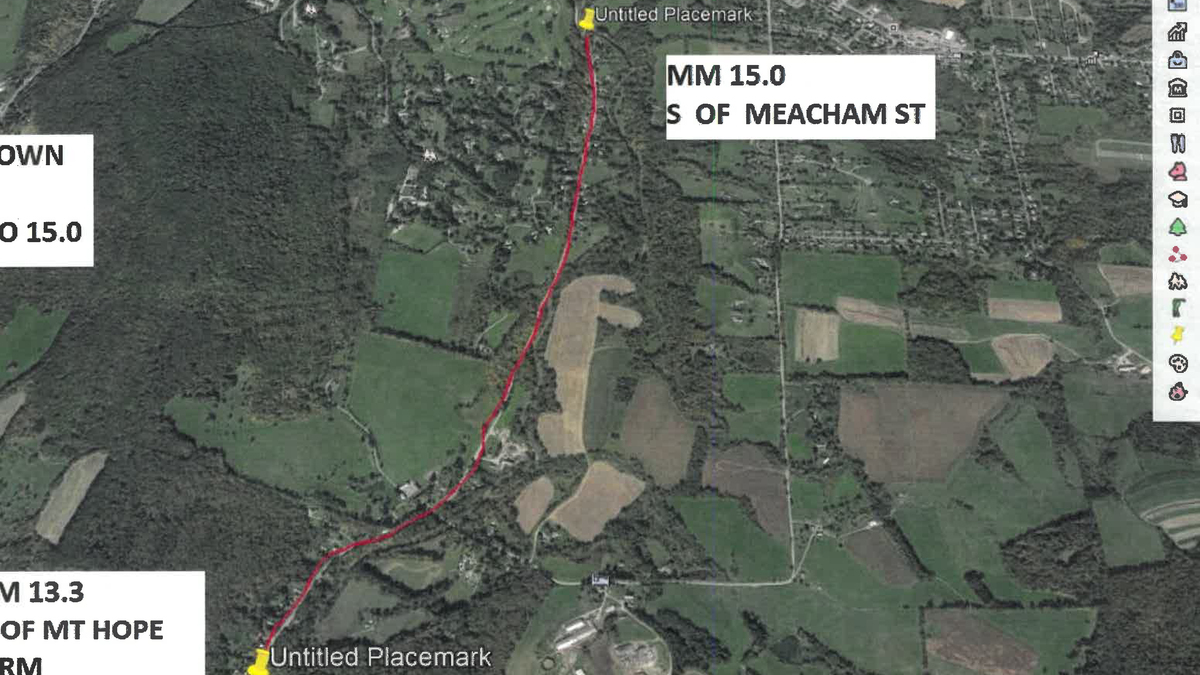
MassDOT design engineer Amer Raza was in front of the town's Conservation Commission last month to get its blessing on a $120,000 "mill and fill" project that will address deficiencies in a 1.7-mile stretch of the road from about the Taconic Golf Club south and west to Mount Hope Park.
"This is just a patch resurfacing for Route 43," Raza said. "We will be milling 2 inches and overlaying 2 inches. This will hold the road for a couple of years until we have that full reconstruction project."
The larger project will see 2.3 miles of the road rebuilt from Hopper Road to Latham Street under a plan that has been under development the last couple of years.
Town Conservation Agent Andrew Groff told the commissioners that the reconstruction project is planned for 2023.
The repair work was before the Con Comm for a determination of applicability of the Wetlands Protection Act given the road's proximity to the Green River. The commissioners made a negative determination, which allows the work to go forward without a more costly Notice of Intent process.
Raza said it likely will get under way in August, and the MassDOT contractors should be able to keep at least one lane open at all times during the spot resurfacing.
The Con Comm at its July 23 meeting decided to take no action and instead continue a public hearing on an NOI brought by a resident of Oblong Road.
Giulio Cavalli is seeking the commission's permission to build a garage in a previously degraded portion of riverfront on his property at 800 Oblong Road.
The garage would have 682 square feet of impact in an area as close as 30 feet to the south bank of Sweet Brook, placing it firmly within the Con Comm's jurisdiction.
His NOI, prepared by Guntlow and Associates, addresses a secondary, unrelated impact on the property, a gravel "loop" drive that existed on the property when Cavalli acquired it. According to his application it is uncertain whether the installer obtained the proper permits for the paved area, which represents about 2,500 square feet of impact in the riverfront.
Cavalli's NOI proposes that he create a mitigation area on his property, a "pollinator and bird friendly habitat area" totaling 6,790 square feet, more than double the impacted area of the garage and driveway.
Longtime Commissioners Hank Art and Lauren Stevens questioned the application for its lack of an alternative analysis to the construction as proposed.
"To me, the NOI seemed incomplete in several ways, that being one," Art said.
"It seems to me if it's a deal-breaker to move the garage to another location, that's unfortunately, but, to me, moving it to another location in this rather large [21-acre] property, one can still be in compliance with the Wetlands and River Protection Acts."
Stevens agreed, saying that it's not "not really our problem" if the landowner does not want to find a different place to build his or her garage.
"It appears they want to use that space for something else and build a new garage in exactly the wrong place," Art said. "To me, the improvement would be getting rid of that pullout [the previously degraded area] and getting it back to native vegetation rather than building a garage on it.
"We've had other projects that claimed they'd be an improvement, and the commission has judged no, it's really not."
Charlie LaBatt of Guntlow said he hoped the commission would understand that, taken as a whole, the project with the planned mitigation area would be an improvement.
"The garage itself may not be an improvement, though it's less corrosive than the lawfully existing driveway portion," LaBatt said. "We were hoping the commissioners would see the area of riverfront [the owners] are trying to enhance with plantings … that would be considered satisfactory and mitigating.
"We specifically put [the garage] where this property is lawfully existing previously degraded riverfront prior to the Rivers Protection Act."
Stevens, who was re-elected to chair the commission at the same Thursday meeting, suggested to LeBatt that he and his client consider amending the application in light of the commissioners' comments, and the panel decided to schedule a site visit in advance of its August meeting, when the hearing will continue.
In other business at the July meeting, the commissioners decided not to blaze an unmarked trail through the town-owned Deans property.
"When I walked the trail, I didn't see the point of formalizing it," Tim Carr said. "I'd be in favor of seeing it used without markings or to revert to forest. It seems to me there are plenty of trails on that piece of land at the moment. People can go out on this land and enjoy it without these [proposed] trails."
Art, who previously had argued against formalizing the proposed trail on land under the Con Comm's care and control, agreed.
"I would like to further ask that the trail not be maintained, that there has been a certain amount of tree felling — trees that have fallen across the road have been cut up — and that should cease," Art said. "Let the trail do whatever it's going to do to heal back into the forest."
Tags: conservation commission, MassDOT, road project, wetlands,