Enjoy these few days of mild weather because a polar vortex is nipping at the region.
A strong cold front pushing through the Midwest and southern Canada is expected to dump snow to the south and west of the Berkshires.
But, the area will be getting the colder temperatures and heavy rain over the weekend.
According to Accuweather, "as a ripple in the jet stream moves from the eastern Great Lakes into the Northeast on Saturday, spotty showers are likely in much of the region. Outside of the very highest elevations where a few snowflakes may fall, most of the precipitation should still be in the form of rain."
The jet stream will make a large loop from Kentucky and Tennessee up and over New England, pushing a warm front ahead of it and pulling windy and colder weather behind.
The National Weather Service in Albany, N.Y., is predicting that the heaviest rainfall will be over the northern mid-Atlantic and Northeast, "where high rain rates could lead to isolated instances of runoff and flash flooding." The Weather Prediction Center has issued a "Marginal Risk of Excessive Rainfall" for portions of the Northeast effective Friday morning through Saturday morning.
NWS has also issued a hazardous weather outlook for Western Mass and Southern Vermont with wind gusts of 40 mph possible. Moderate to heavy rainfall is expected Friday and there's a potential for severe thunderstorms in South Berkshire.
Temperatures over the weekend should remain in the 50s and high 40s but are expected to drop slightly on Monday bringing the potential for — wait for it — snow showers.
The rest of the week should be partly sunny with temperatures more usual for November.
After a stormy afternoon/eve tomorrow, another system dives in on Saturday eve
This one looks very potent. Could see some lightning and downpours...and perhaps a mixed bag of things falling from the sky (rain, hail, snowflakes across high terrain to end?) pic.twitter.com/NWBmkopbl1
The pattern of storminess we're seeing now across the northern U.S. is probably a sign of things to come. The cold, stormy weather in the Pacific NW and Upper Midwest is exactly what's typical during La Nina winters. (4/4) pic.twitter.com/2cw2YscIdI
If you would like to contribute information on this article, contact us at info@iberkshires.com.
Your Comments
iBerkshires.com welcomes critical, respectful dialogue. Name-calling, personal attacks, libel, slander or foul language is not allowed. All comments are reviewed before posting and will be deleted or edited as necessary.
No Comments
Friday Front Porch Feature: A Charming House Like New
By Breanna SteeleiBerkshires Staff
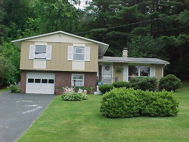
The home prior to renovations.
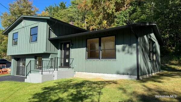
NORTH ADAMS, Mass. — Are you looking for a newly renovated home with great space? Then this might be the perfect fit for you!
Our Friday Front Porch is a weekly feature spotlighting attractive homes for sale in Berkshire County. This week, we are showcasing 100 Autumn Drive.
This three-bedroom, two-bathroom split level was built in 1965 and is 1,396 square feet on 0.32 acres.
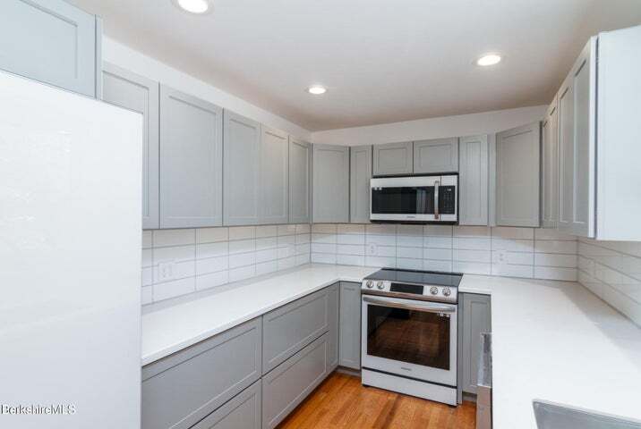
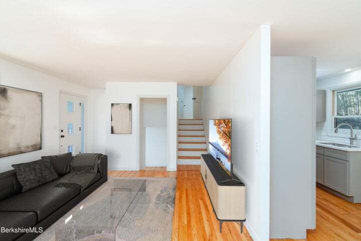
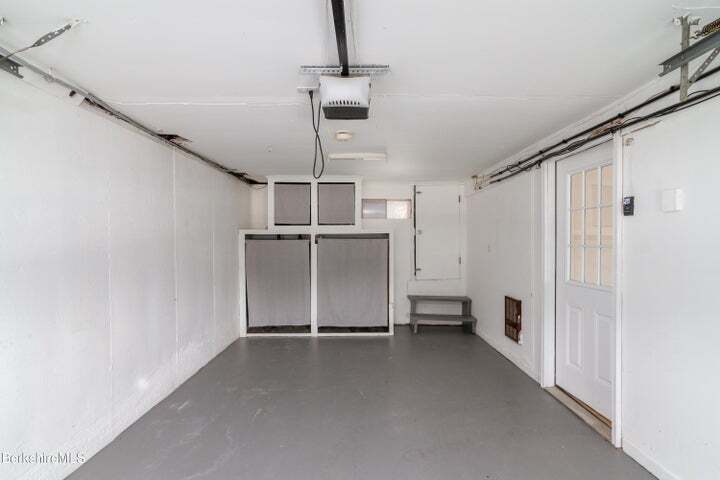
The house was completely renovated recently. It includes a one-car garage, and comes with appliances including a dishwasher and stove/oven, and other major appliances.
The house is listed for $359,500.
We spoke with owners Michael Zeppieriand Chris Andrews, who did the renovations. Zeppieri is an agent with Alton and Westall Real Estate Agency.
What was your first impression when you walked into the home?
Zeppieri: I purchased this home to do a full renovation flip and saw tremendous potential in this mid-century split level home that had not been updated since it was built in the 1960s, in a great North Adams neighborhood.
Andrews: The house was a much different house when we first purchased it in 2022 (photo attached is from about 2010.) The interior was painted all in dark colors and we brightened it up with neutral colors. The transformation makes you feel like you are in a totally different house.
What were the recent renovations, any standout design features?
Zeppieri: The house has had a complete reconfiguration including new kitchen with high-end appliances, ceramic tiled baths, hardwood floors, new windows and roof ... just to name a few. All a buyer has to do is move in and enjoy.
Andrews: Yes, we renovated the entire house. New windows, new roof, all new custom black gutter system, new blacktop driveway, hardwood floors were installed through out the house. New kitchen and bathrooms as well as painting the exterior and interior of the house. New paver patio in the back yard.
What kind of buyer would this home be ideal for?
Zeppieri: The buyer for this home could be a first-time homebuyer or a retiree ... the location is close to attractions in North Adams ... and the property is located in Autumn Heights, which is a very small residential development with several long-term owners.
Andrews: This home is truly ideal for a variety of buyers. Whether a first-time homebuyer, a small family or even someone looking to downsize from a larger home.
What do you think makes this property stand out in the current market?
Zeppieri: The location, price and move-in condition of this home make it a true market leader in the North Adams Market.
Andrews: This house is completely renovated and in a desirable location of North Adams. The natural light in the home really makes the interior pop. And with all the upgrades the home stays quite cool in the summer months.
Do you know any unique stories about the home or its history?
Zeppieri: This home was built for the Gould family in 1969 and they lived there till 2010. It was always a family home during that time in which the Goulds had two children ... and Virgina Gould managed Mohawk Forest Apartments and was a very active resident of North Adams.
Andrews: Built in about 1965.
What do the current owners love about this home?
Zeppieri: As the current owner it was a fun project to transform this home and get it ready for its next adventure with a new family to enjoy for many years.
Andrews: No one has lived in the house since we purchased the home. The new owners would be the first to live in the house since the renovations have been completed.
What would you say to a buyer trying to imagine their life in this space?
Andrews: I would suggest seeing the house either on a sunny day or at twilight to really get a vision of how special the home feels.
You can find out more about this house on its listing here.
*Front Porch Feature brings you an exclusive to some of the houses listed on our real estate page every week. Here we take a bit of a deeper dive into a certain house for sale and ask questions so you don't have to.
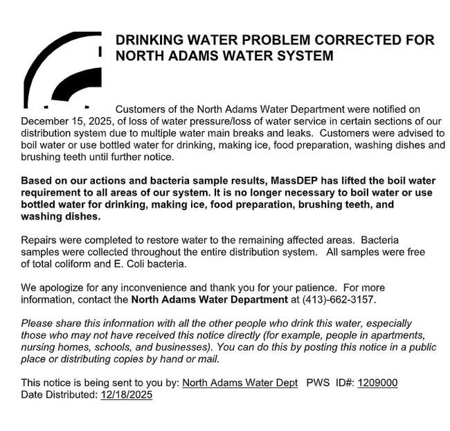
The city has lifted a boil water order — with several exceptions — that was issued late Monday morning following several water line breaks over the weekend. click for more
The bridge had been closed to all vehicle traffic since March 2023 after being deemed structurally deficient by the state Department of Transportation. click for more