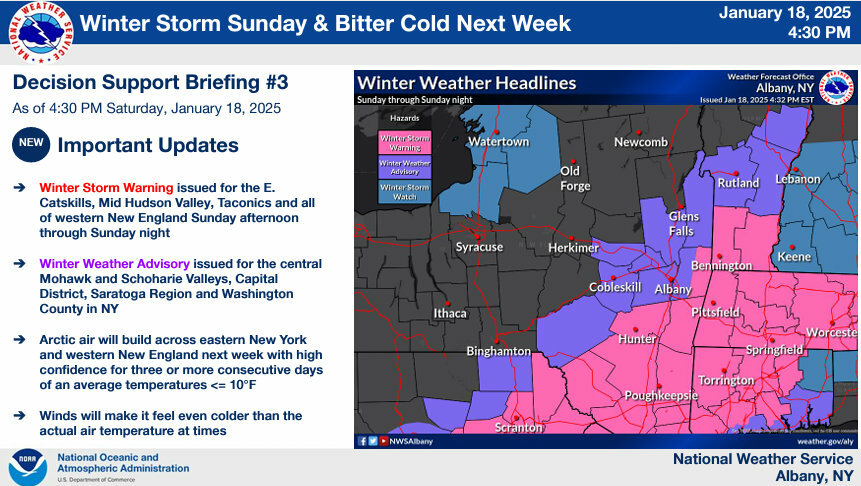
Weather Alert: Berkshires Getting Snow, Frigid Temperatures
The Berkshires is line for 6 to 8 inches of snow to fall across the region beginning Sunday afternoon and into Tuesday morning.
This will be followed by another blast of Arctic air that will sent temperatures plummeting.
All of Massachusetts, Southern Vermont, eastern New York and Connecticut are under storm warnings or advisories. A winter storm warning is in effect for the Berkshires beginning at 1 p.m. Sunday to 7 a.m. Monday.
Snowfall rates of up to an inch an hour is expected by early Sunday evening.
Winter parking rules are already in effect and communities including North Adams have instituted a snow emergency, which means no parking on the streets during the storm.
In Pittsfield, parking is allowed on the odd side of the street from 7 a.m. Sunday to 7 a.m. Monday and on the even side from 7 a.m. Monday to 7 a.m. Tuesday to accommodate snow removal. Downtown residents are encouraged to use the McKay Street garage, which is available free during the snow emergency.
The National Weather Service is also predicting bitter cold temperatures early in the week, with wind chills between 0-10 degrees Fahrenheit on Monday through Wednesday night.
Monday is Martin Luther King Jr. Day so town and city offices, libraries, public schools, banks and post office will be closed so we do not anticipate any closing lists.
We will post any cancellations of activities for Monday on our Facebook page.
The state Department of Transportation is advising travelers to allow for extra travel time and check forecasts for their routes and destinations. With widespread snowfall amounts forecast, MassDOT crews will be pretreating roadways in advance of the storm and will be deploying snow removal staff and equipment as necessary across the commonwealth.?
Clear snow and ice from your vehicle's windows, lights, hood and roof before driving. Utilize safe winter driving practices, including leaving extra room for braking and stopping in slippery travel conditions. Don't crowd the plow or maintenance vehicles. Stay back at least 200 feet and don't pass on the right.
Take stock of your emergency kit and ensure it includes seasonal supplies, such as extra winter clothing and blankets.
At home, prepare for possible power outages. Fully charge your cellphone, laptop, and any essential electronic devices before the storm. Ensure you have extra batteries for medical equipment and assistive devices.
Manually check your smoke and carbon monoxide (CO) detectors to make sure they work correctly and have fresh batteries. During and after the storm, check your outside fuel exhaust vents, making sure that they are not obstructed by snow or ice.
"As we continue to monitor this storm, we want everyone to be prepared and plan accordingly, especially residents and visitors that may have plans to travel over this holiday weekend," said Gov. Maura Healey. "We advise you to use extra care on the roads Sunday into Monday morning and take the time to check in on your neighbors to make sure everyone stays warm and safe."
Guidance is honing in on a track between Cape Cod & benchmark. This represents a slight east trend.This supports a widespread 4-8".Downeast Maine is on track for the most. Read our full,detailed forecast update here: #MAwx #CTwx #RIwx #NHwx #MEwx #VTwx www.newenglandstormcenter.com/post/snow-se...
— New England Storm Center (@nestormcenter.bsky.social) January 19, 2025 at 10:08 AM
[image or embed]
We have a snow deficit so far this winter, but we are about to make up ground! A solid half a foot from about 4 pm to midnight tonight. pic.twitter.com/FgtDKEmwDi
— Dan Brown (@dbrownweather) January 19, 2025
We have a snow deficit so far this winter, but we are about to make up ground! A solid half a foot from about 4 pm to midnight tonight. pic.twitter.com/FgtDKEmwDi
— Dan Brown (@dbrownweather) January 19, 2025
Tags: snowstorm,