Storm Brings Flooding, Tornado Warnings
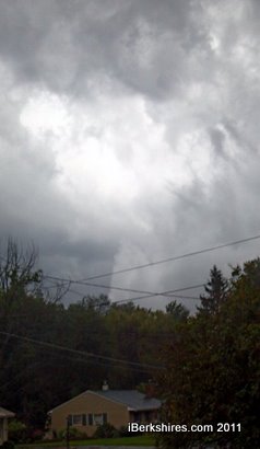 Reporter Andy McKeever tooks shots of what appeared to be a funnel cloud forming in the Pittsfield area. |
A severe thunderstorm warning was posted from late this afternoon until 9 p.m. There were at least two reports of possible funnel clouds, one at about 7:03 moving northeast toward Pittsfield at about 35 mph and another around 7:26 in the Savoy/Windsor area.
The tornado warning was lifted at 7:45.
A flash flood warning is in effect until 10:45 for Central Berkshire. There were scanner reports of flooding at low-lying spots throughout Pittsfield, including the Allendale intersection, and some trees and poles down. Pittsfield dispatch was too busy to answer questions.
Flood warnings for small stream and poor drainage areas is in effect until 1 p.m. Motorists are advised to proceed with caution; flooded areas may be deeper than they appear.
A severe thunderstorm was tracking from Copake, N.Y., through Southern Berkshire before 9 p.m.
The National Weather Service has not confirmed tornado touchdowns as of yet, but there were sightings of dark funnel clouds southeast of Pittsfield in the hilltowns. Several attempts so far to contact Windsor and Savoy fire departments returned busy signals.
iBerkshires Senior Reporter Andy McKeever saw what looked like tornadic activity near Pittsfield at about 7:10-15 and took pictures from Route 7 looking north toward Route 8. He said there were low, dark swirling clouds in something like a tunnel formation.
The county has been taking tornado warnings very seriously after at least two funnel clouds hit parts of Springfield, Monson and some smaller towns in the next counties over earlier this spring. Earlier on Sunday afternoon, a tornado is believed to have caused severe damage to the small town of Goderich, Ontario.
Tags: storm, tornado,