Wednesday Presentation to Give Alternatives for Bennington-Williamstown Bike Path Idea
It will be some time before the Ashuwilticook Rail Trail is extended in Massachusetts from Adams through North Adams to link with a crosstown trail set to break ground in Williamstown next year.
And it will be years before a similar path could be built in Southwestern Vermont.
But that proposed journey of 35 miles takes a lot of steps, even before shovels go in the ground.
And on Wednesday at 5:30 p.m., the Bennington County Regional Commission will host an online presentation to look at possible routes for a path that takes advantage of a trolley route that operated in the area in the first decades of the 20th century.
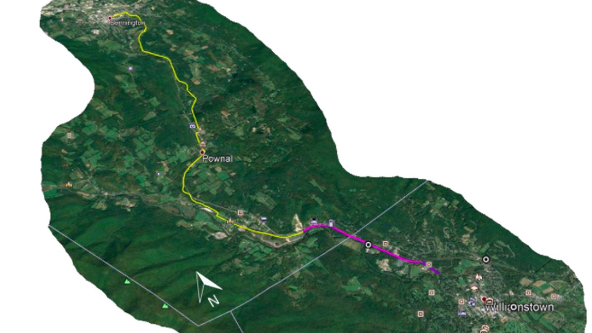
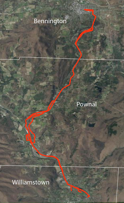
The commission is looking at feedback on its idea to create a path that would cover about 12 miles -- nearly as much terrain as the current Ashuwilticook and a little more than the route from Williamstown's Syndicate Road through North Adams on a route to be determined and to the current trail head in Adams.
BCRC Senior Planner Catherine Bryars on Monday emphasized that the Bennington-to-Williamstown leg is still in the scoping phase.
"It's going to take a long time to figure out if it goes forward," Bryars said. "As we share the alternate routes we've considered, what we're looking for is: Are we on the right track? Are these viable options?
"In the final report, we will identify a preferred route. We will indicate where we're leaning and if people have a strong feeling that one should be weighted over the other."
While planners hope to take advantage of a lot of the trolley route in Vermont, the landscape changes south of the state line and there are a few different alternatives for getting a route that runs along the west side of Route 7 across the U.S. highway to link up with the trail from Syndicate Road that already has funding and permitting in place.
"The presentation we're gearing up for on Wednesday is going to be looking at a lot of alternatives that are being considered, and even in the final scoping report, there is a preferred alignment that we identify, but we also will outline several alternatives," Bryars said. "For the area you're talking about down in Williamstown, to get from the north of the Hoosic [River] to the south of the Hoosic, there are three different routes that we're considering.
"One of them would be to go under the Route 7 bridge and connect to the Syndicate Road to the pathway."
Once the planners nail down a preferred route, they will have other hurdles to overcome, including environmental permitting and acquisition of rights-of-ways on numerous private parcels that will be needed.
Bryars said her agency is holding off on the latter piece for now.
"We haven't yet, but we are going to start [those conversations] before the scoping report is finalized," she said. "We were weighing when to reach out [to landowners] and decided we were going to do [Wednesday's] alternatives presentation first to make sure that we have identified the most viable alternate routes.
"Once we have those and we have the public comment to make sure we're moving in the right direction, then we can reach out to the potentially affected landowners. But to do that ahead of time without having really publicly assessed what the routes are that are on the table -- that's why we're going in the order we're going."
Bryars said she expects to start contacting landowners within the next couple of weeks.
Environmental impacts will require a whole set of conversations with regulators in both states.
"One thing in particular about the alignment is … that trolley line happens to run in the buffer areas of rivers and wetlands," Bryars said. "There's been river corridor regulations in Vermont since 2015, and those are pretty stringent. They're designed to allow a fluvial erosion hazard area around rivers, kind of a buffer for the river to move naturally over time, which is a great idea. It's totally ecologically oriented, which is probably what it should be.
"But part of saying no development is allowed in those areas is, those are some of the best places to put pathways, to give people access to those natural green areas that otherwise aren't going to be developed. It's an ongoing conversation with state environmental regulators to what extent paths should be included in these areas or not."
The Massachusetts leg comes with its own property owner and environmental concerns.
"The right-of-way would be with the railroad, and then the other challenge on some of the town-owned properties we'd be going through potentially … historically those are all landfills," said Williamstown Community Development Director Andrew Groff, who is coordinating with Bryars on the proposal. "Just like we've done for the [new] path, where it goes from Syndicate Road into the college campus by the softball field, that goes over a closed landfill. So we had to get special regulatory approval from Mass DEP's solid waste division in addition to the wetlands division and the local Conservation Commission.
"It's tough to figure out a way to get it through Williamstown otherwise. There was some thought to looking at the far side of the Hoosic, but the terrain is much too challenging over there."
Bryars said she does not know how much the proposed path might cost but will have a ballpark estimate by the time BCRC submits its final scoping report.
The project, which has been in the works since 2018, is funded by a grant from the Vermont Agency of Transportation and is meant to address the fact that Route 7 itself is not compatible with complete streets, a planning and design approach that facilitates walkers and bikers.
Funding the full project likely will require coordination of the Vermont Department of Transportation with the Massachusetts Department of Transportation, which is paying for the Williamstown-to-North Adams trail that is planned to break ground in the spring of 2021.
Bryars said Monday she did not know if a bi-state project would be breaking ground of a different kind.
"We're going to be working with a couple of students at Williams College, and they're going to pick up several pending research questions we have to help us out with the study," she said. "One of the questions we're hoping they might look into is to identify other case studies of where there has been interstate coordination of developing a path like this. Has there been a successful model.
"Up until now, the conversation has been, we can only imagine these two processes going forward separately, but you don't want to have the end result be one side is built and the other side isn't."
The Wednesday 5:30 p.m. alternatives presentation can be accessed through the Williamstown website here.
Tags: Ashuwillticook Rail Trail, bike path, trails,