image description

Snow Possible for Berkshires on Friday

Print Story | Email Story

The forecast for this week is "soggy and dreary," according to Accuweather, but don't worry, there's a snowstorm on the way as well.
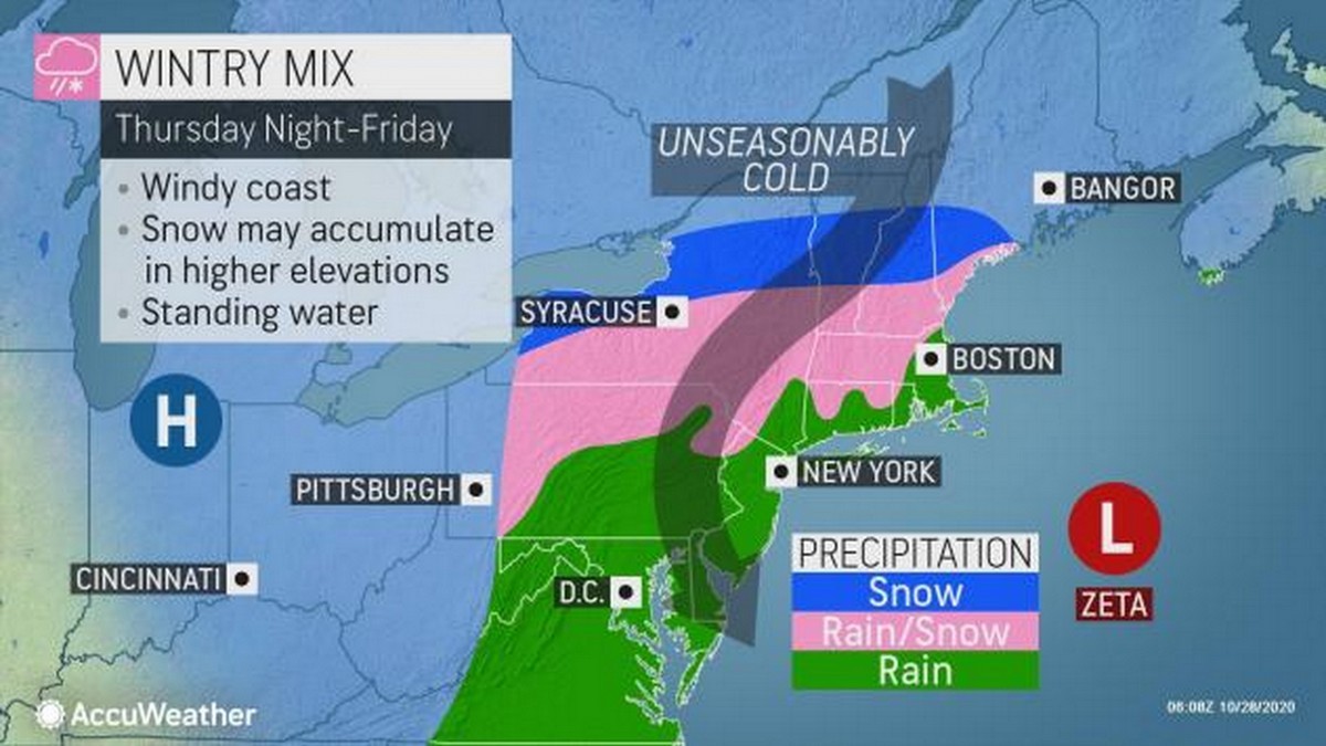
A combination of a winter storm heading eastward and Tropical Storm Zeta moving up the coast will bring drenching rain and potential snow for the Berkshires and Southern Vermont.
 
"With a full changeover to snow now anticipated over the mountains, a moderate to heavy accumulation is appearing more likely over the higher terrain into Friday. Such a scenario could weigh down trees that still have a canopy of leaves and lead to power outages," according to Accuweather.
 
However, a high pressure system could push the wet weather farther east and out to sea by Saturday night, just in time for trick or treating. The rain may leave but the temperatures will still be chilly — 5 to 10 degrees below normal for the end of October.
 
The National Weather Service is predicting a 50 percent chance that more than 2 inches of snowfall will cover the Berkshires and Southern Vermont between Wednesday and Saturday, although most weather predictions are that the storm system will move out by Friday afternoon.
 
Rain late Thursday is expected to mix with snow as the colder air arrives with accumulations in the higher regions but there's also the possibility the valleys may see a covering of snow.  
 
The latest forecast from NWS is 1 to 2 inches in the higher elevations but with the 10 percent chance of 5 to 7 inches in North Berkshire and Southern Vermont. 
 
Greylock Snow Day wakened from its long hibernation on Wednesday to make some predictions — and advocate for snow days in this virtual education world. 
 
"For an October snow event, this storm has some steam. Early season storms are always hard to predict because there often is no snow pack or base of cold air, which somewhat explains the wide range of predicted snowfall," writes the blog. "It has the feel of the October 29-30 storm of 2011 that dropped over a foot in South County and over 6 inches in North County."
 
Friday morning commutes from the living room to the kitchen may be treacherous it warns. 
 
Greylock Snow Day says the "home office" will remain open but implores readers to contact their school officials to "retain the sacred snow day." No Zoom, no remote, just a snow day. 

Tags: snowstorm,   

If you would like to contribute information on this article, contact us at info@iberkshires.com.

Nor'easter Set to Drop Foot of Snow Over Berkshires

Update on the powerful Nor'easter set to drop up to a foot of snow over the region. This come right on the tail Friday's storm that dropped up to 6 inches in some areas. 
 
The National Weather Service in Albany, N.Y., has shifted the winter storm warning issued from Saturday a few hours later; it now begins at 4 p.m. on Sunday  but still runs through 7 p.m. on Monday for the Berkshires, eastern New York, Southern Vermont and northern Connecticut.
 
Heavy snow expected with total accumulations between 8 and 14 inches with some locally higher totals possible over the high peaks of the Catskills AND the Berkshires. Winds could gust as high as 50 mph. 
 
The forecasted "bomb cyclone" is lining up to hit New York City with its first blizzard in a decade, but Western Mass will feel some of its effects.  
 
The Berkshires will see flurries during the day but the Nor'easter will make its entrance later in the evening, first in South County between 5 and 8 and then moving north.
 
Vermont schoolchildren will be starting their winter vacation Monday but Berkshire kids will be headed back to school. But they might be getting an extra vacation day — Greylock Snow Day still has an 80 percent probability for of delays, but upgraded the chance of a snow to 90 percent for South County and 75 percent for north. 
 
With the storm sweeping in by Sunday afternoon, we'll be on the lookout for any cancellations. This post will also be updated if new information becomes available. 
 
View Full Story

More North Adams Stories