image description

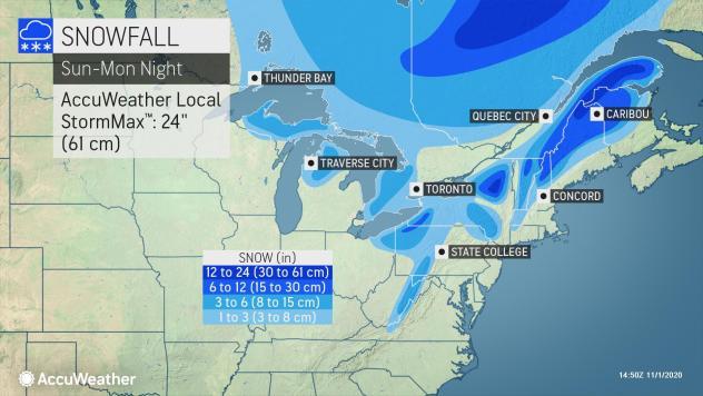
Dig Out the Snow Shovels: Storms Could Drop 3-8 Inches

Print Story | Email Story
Mother Nature's dusting of snow and ice over Halloween just wasn't scary enough. Now she's getting more serious with a strong chance of up to 8 inches over the next two days. 
 
The National Weather Service in Albany, N.Y., has issued a winter weather advisory from 7 p.m. on Sunday through Tuesday morning with snow accumulations ranging from 3 to 8 inches in Southern Vermont and the Northern Berkshire.
 
Reminder: Winter Parking Bans go into effect beginning Sunday for most communities in the Berkshires. That means no overnight parking on the street and no parking on the street during snowstorms so that plows can get through. Violators may find their vehicles ticketed and/or towed. 
 
Accuweather says a "potent cold front" now over the Great Lakes will bring blustery winds and precipitation over the Northeast into Election Day. 
 
"Temperatures can be 10-15 degrees Fahrenheit below normal in the Northeast and northern mid-Atlantic on Monday," AccuWeather Senior Meteorologist David Samuhel said.  
 
Strong winds may cause damage with downed trees and wires so there's the potential of power outages in some areas. 
 
There are two systems that will affect weather over New England: the cold front coming from the Great Lakes and a weaker storm moving south from Canada. 
 
But expect the cold to move out pretty quickly as a warming trend begins midweek that will drive temperatures back up in the 60s. 

Tags: snowstorm,   

If you would like to contribute information on this article, contact us at info@iberkshires.com.

Nor'easter Set to Drop Foot of Snow Over Berkshires

Update on the powerful Nor'easter set to drop up to a foot of snow over the region. This come right on the tail Friday's storm that dropped up to 6 inches in some areas. 
 
The National Weather Service in Albany, N.Y., has shifted the winter storm warning issued from Saturday a few hours later; it now begins at 4 p.m. on Sunday  but still runs through 7 p.m. on Monday for the Berkshires, eastern New York, Southern Vermont and northern Connecticut.
 
Heavy snow expected with total accumulations between 8 and 14 inches with some locally higher totals possible over the high peaks of the Catskills AND the Berkshires. Winds could gust as high as 50 mph. 
 
The forecasted "bomb cyclone" is lining up to hit New York City with its first blizzard in a decade, but Western Mass will feel some of its effects.  
 
The Berkshires will see flurries during the day but the Nor'easter will make its entrance later in the evening, first in South County between 5 and 8 and then moving north.
 
Vermont schoolchildren will be starting their winter vacation Monday but Berkshire kids will be headed back to school. But they might be getting an extra vacation day — Greylock Snow Day still has an 80 percent probability for of delays, but upgraded the chance of a snow to 90 percent for South County and 75 percent for north. 
 
With the storm sweeping in by Sunday afternoon, we'll be on the lookout for any cancellations. This post will also be updated if new information becomes available. 
 
View Full Story

More North Adams Stories