
Weekend: Snow, Cold, Snow
 |
The weather continues to be on repeat for the weekend: snow, frigid cold, followed by more snow.
There's a chance of snow on Wednesday evening and Thursday morning. A clipper system will bring Arctic temperatures to the Northeast with lows in the teens and single digits over the weekend.
A major snowstorm is forecast beginning sometime Saturday through Sunday, possibly the "most impactful winter storm" this winter, if not in several years, according to CBS News.
Right now, the bulk of the accumulation will be along the mid-Atlantic, where the clipper will meet warm, wet air from the south Pacific. This could mean a foot or more of snow in places like Virginia, Kentucky and Tennessee.
Accuweather is predicting 3 to 6 inches across Massachusetts and Southern Vermont, but if the storm shifts north, the region could see closer to a foot.
Greylock Snow Day has a 5 percent probability for a snow day on Monday, but notes that this could change as the storm system develops.
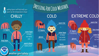
In any case, it's best to prepare for the worst: stay warm, bring pets in and check on elderly neighbors and family members. The Red Cross has some suggestions for keeping safe this weekend.
A severe Arctic blast this weekend will bring wind chills well below zero for New England. In the midst of this will be a storm moving thru the Mid-Atlantic, with questions about how far north impacts will spread. #MAwx #CTwx #RIwx #NHwx #MEwx #VTwx newenglandstormcenter.substack.com/p/strong-arc...
— New England Storm Center (@nestormcenter.bsky.social) January 21, 2026 at 8:58 AM
[image or embed]