Weather Advisory: Snow, Rain, Wind on the Way
.jpg)
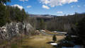
Wet conditions continue to advance northeastward #nywx #ctwx #mawx #ctwx as coastal storm intensifies. Rainfall amounts the past 6-hours upstream have been over one-half of an inch. Some snow across the higher terrain remains possible this afternoon. pic.twitter.com/CY87jjYOVk
— NWS Albany (@NWSAlbany) March 21, 2019
Rain today..some mixing in the mountains but the bigger problems come tomorrow! Friday= Rain and a rain/snow mix in the Capital District while the mountains and higher elevation have steady, heavy snow. Strong winds will be a problem Friday-Saturday. Stay tuned & stay updated! pic.twitter.com/1tGWkyRmLy
— Jess Briganti (@JessBriganti) March 21, 2019
Our updated #AccuWeather storm snowfall map in cm's and inches. Highest amounts will likely be in the high elevations of the northern Adirondacks. Amounts will be very elevation dependent (typical for early spring). pic.twitter.com/OcJLqSJQSW
— Brett Anderson (@BrettAWX) March 21, 2019
Tags: bad weather, snowstorm,