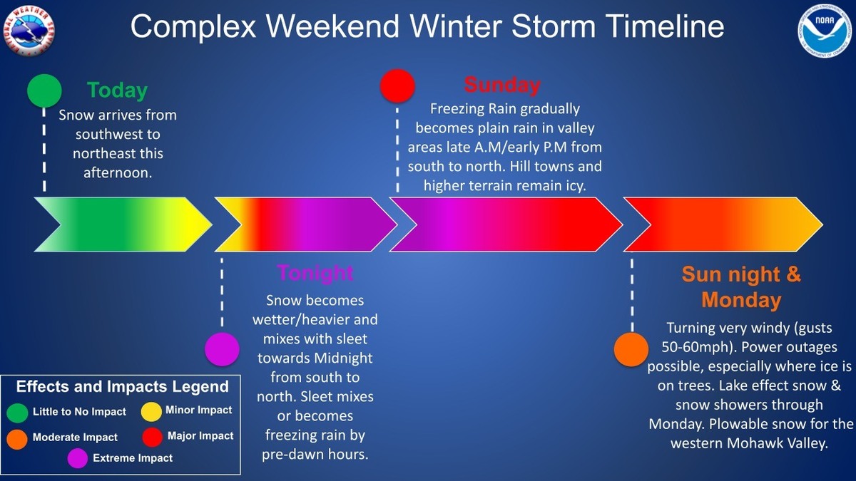
Another weekend, another storm for the Berkshires.
The National Weather Service in Albany, N.Y., is forecasting 3 to 7 inches of mixed precipitation beginning Saturday afternoon. Ice accumulations may be between one-tenth and three-tenths of an inch.
A winter weather advisory is in effect from 1 p.m. on Saturday to 7 p.m. on Sunday.
Snow will continue through this evening before transitioning to a wintry mix overnight into Sunday afternoon. Some areas may change over to plain rain before precipitation tapers off.
This expected to followed by high winds Sunday night with gusts reaching up to 60 mph. Strong winds combined with any ice on trees could result in additional power outages. A high wind watch is in effect from 7 p.m. Sunday through Monday evening.
Roads, and especially bridges and overpasses, will likely become slick and hazardous from snow, sleet and ice accumulations. Plan on slippery road conditions. Power outages and tree damage are possible due to the ice, snow and winds.
North Adams, Pittsfield and other communities have declared snow emergencies which means no parking on the street. In Pittsfield, parking is allowed only on the odd side of the street on Saturday beginning at 7 a.m. and the even side, also beginning at 7 a.m., on Monday. Downtown residents are being encouraged to the McKay Street parking garage free of charge during the emergency.
Travelers should allow for extra travel time and check forecasts for their routes and destinations and, if possible, consider using public transportation in place of a personal vehicle. MassDOT crews have been pretreating roadways in advance of the storm and will be deploying snow removal staff and equipment as necessary across the commonwealth. Download the?Mass511?mobile app or visit?www.mass511.com?to view live cameras, travel times, real-time traffic conditions.
National Grid is preparing for icing, snow, hazardous winds and cold temperatures. Wind gusts have the potential to damage trees and knock down power lines, causing power outages in impacted locations. Icing can lead to sagging powerlines and tree limbs. The timing of the changeover to snow and freezing rain will influence snow and ice amounts, with higher snow totals across Western Massachusetts.
Avoid dangerous downed powerlines; report power outages at www.nationalgridus.com or call 1-800-465-1212. Use your mobile device to track outage information and storm-related safety tips through National Grid's mobile site, accessible at www.ngrid.com/mobile.
"National Grid has been tracking this storm for several days and we have crews and personnel ready to respond to any impacts from the weather," said Shaun Vacher, vice president of electric operations, New England. "In the event of outages, our crews and support teams will be working for as long as needed to restore service as quickly and safely as conditions allow."
A look at alerts as we head into this messy storm. It's increasingly likely that it will turn very windy on the backside of the storm into Monday. With some icing and little melting, this could be an issue #MAwx #CTwx #RIwx #NHwx #MEwx #VTwx
February 14-15th, 1940: A Valentine's Day blizzard hit the northeastern United States with 10 to 18 inches of snow over southern New England. It took 17,000 men on the 15th to shovel out Boston. www.newenglandhistoricalsociety.com/valentines-d...
If you would like to contribute information on this article, contact us at info@iberkshires.com.
Your Comments
iBerkshires.com welcomes critical, respectful dialogue. Name-calling, personal attacks, libel, slander or foul language is not allowed. All comments are reviewed before posting and will be deleted or edited as necessary.
No Comments
RFP Ready for North County High School Study
By Tammy Daniels iBerkshires Staff
NORTH ADAMS, Mass. — The working group for the Northern Berkshire Educational Collaborative last week approved a request for proposals to study secondary education regional models.
The members on Tuesday fine-tuned the RFP and set a date of Tuesday, Jan. 20, at 4 p.m. to submit bids. The bids must be paper documents and will be accepted at the Northern Berkshire School Union offices on Union Street.
Some members had penned in the first week of January but Timothy Callahan, superintendent for the North Adams schools, thought that wasn't enough time, especially over the holidays.
"I think that's too short of a window if you really want bids," he said. "This is a pretty substantial topic."
That topic is to look at the high school education models in North County and make recommendations to a collaboration between Hoosac Valley Regional and Mount Greylock Regional School Districts, the North Adams Public Schools and the town school districts making up the Northern Berkshire School Union.
The study is being driven by rising costs and dropping enrollment among the three high schools. NBSU's elementary schools go up to Grade 6 or 8 and tuition their students into the local high schools.
The feasibility study of a possible consolidation or collaboration in Grades 7 through 12 is being funded through a $100,000 earmark from the Fair Share Act and is expected to look at academics, faculty, transportation, legal and governance issues, and finances, among other areas.
The city has lifted a boil water order — with several exceptions — that was issued late Monday morning following several water line breaks over the weekend. click for more
The bridge had been closed to all vehicle traffic since March 2023 after being deemed structurally deficient by the state Department of Transportation. click for more
The Water Department has been responding to multiple water line breaks throughout the city since Friday, causing temporary loss of water in some areas. click for more
Nearly a year of study and community input about the deteriorating Veterans Memorial Bridge has resulted in one recommendation: Take it down. click for more