Thunderstorms and heavy rain can be expected late Wednesday throughout Berkshire County.
This afternoon and evening, thunder and lightning will roll across the region.
In North County, expect clouds and temperatures in the 70s. A thunderstorm is expected around 7 p.m. Accuweather warns that the storm could bring hail and damaging winds. Storms are expected to continue sporadically throughout the night.
Central and South County can also expect some weather around the same time.
WTEN Meteorologist Steve Caporizzo said to "Watch for showers-Heavier T'storm tomorrow afternoon-Evening. More Widespread Showers for Thursday Huge temp contrast Wednesday....Low 60s Adirondacks to the mid 80s in NYC."
Accuweather predicts rain throughout the day Thursday. Temperatures should stay in the 60s.
The weather pattern this week is more typical of June and not only because of the warmth, but also the nature of the storms on the way, AccuWeather Meteorologist Jake Sojda said.
"Temperatures will peak at levels more typical of late June over much of the Ohio Valley, central Appalachians and mid-Atlantic regions on Wednesday," Sojda explained. "We also often see potent storms sag southward into that warm air during June," adding that is similar to the pattern expected to unfold later Wednesday into Thursday.
More rain should be expected Friday. Berkshire County can expect passing showers with wind and cooler temperatures in the 50s.
This weekend should be mostly cloudy. Temperatures are expected to stay within the 50s Saturday.
Some rain is expected in North and Central County Sunday, but temperatures should break into the 60s.
An early look at next week looks promising with some sun and temperatures in the 60s and 70s.
This is Severe Weather Awareness Week and the National Weather Service says the most frequently occurring summer hazardous weather is lightning and offers the following warning:
"All thunderstorms contain deadly lightning. Postpone outdoor activities if you can hear thunder. Move to a sturdy building or hard topped vehicle. Stay away from tall objects such as towers, isolated trees and telephone poles. If caught outdoors in a remote area, find a low spot. Make sure your choice is not susceptible to flooding. If in the woods, take shelter under smaller trees. If you are boating or swimming, seek shelter on land immediately. When thunder roars, go indoors!"
The Storm Prediction Center has expanded the Marginal Risk of severe thunderstorms for late this afternoon to include most of the Capital Region. Heavy downpours, strong wind gusts and lightning are all possible. @WNYTpic.twitter.com/fXMzyDI4I4
Watching a line of thunderstorms move across NY this afternoon. Arriving in western Mass around 5-8pm with some downpours and possible hail/damaging wind gusts. #mawxpic.twitter.com/ieYsWPsvGo
That's about right, upper 50s right now in the Adks. and around 80° at Kingston. Showers and t'storms will overspread the region this afternoon and evening, There is a potential a few could be severe, mainly in the warmer air mass to the south. pic.twitter.com/ZwxXFKEwDF
If you would like to contribute information on this article, contact us at info@iberkshires.com.
Your Comments
iBerkshires.com welcomes critical, respectful dialogue. Name-calling, personal attacks, libel, slander or foul language is not allowed. All comments are reviewed before posting and will be deleted or edited as necessary.
No Comments
Berkshire Food Project Closed for Power Issues
NORTH ADAMS, Mass. — The Berkshire Food Project is closed Monday because of a power outage early in the morning.
"We are unable to get proper electricity and heat to the building," according to Executive Director Matthew Alcombright. "We hope that this can be resolved and be open tomorrow."
The project does have some sandwiches and frozen meals that will be distributed at the entry.
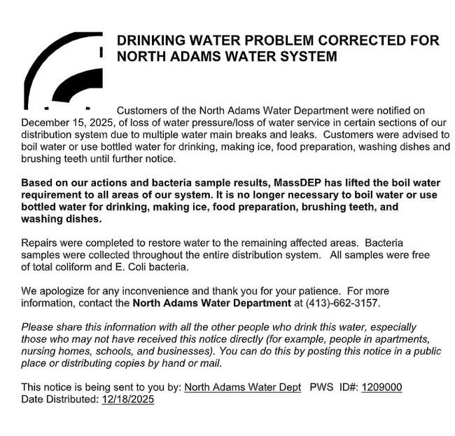
The city has lifted a boil water order — with several exceptions — that was issued late Monday morning following several water line breaks over the weekend. click for more
The bridge had been closed to all vehicle traffic since March 2023 after being deemed structurally deficient by the state Department of Transportation. click for more